
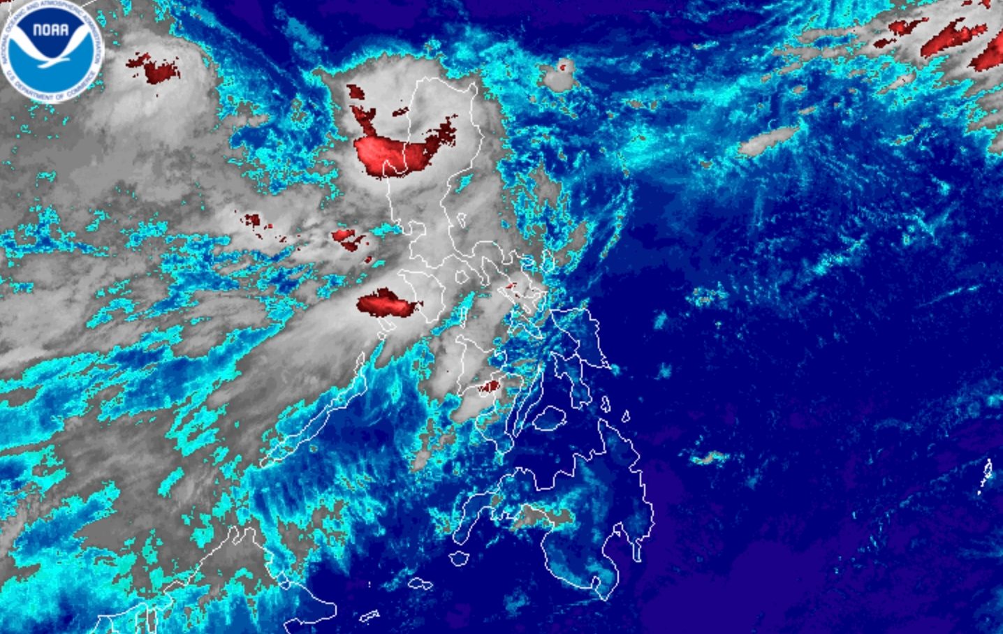
MAYMAY. Satellite image of Tropical Storm Maymay (Kujira) as of August 6, 2026, 7 am. NOAA Tropical Storm Maymay (Kujira) is in the vicinity of Bangued, Abra, as of 7 am on Thursday, August 6 MANILA, Philippines – Tropical Storm Maymay (Kujira) began crossing Northern Luzon early Thursday morning, August 6, following its landfall in Magsingal, Ilocos Sur, at 2 am. The Philippine Atmospheric, Geophysical, and Astronomical Services Administration (PAGASA) said in a bulletin issued at 8 am that Maymay was already in the vicinity of Bangued, Abra, as of 7 am, moving east at only 10 kilometers per hour (km/h). Maymay slightly weakened before dawn, with its maximum sustained winds down to 65 km/h from a peak of 75 km/h. Its gustiness is currently up to 110 km/h. PAGASA said Maymay is likely to be downgraded to a tropical depression, then weaken into a low pressure area, on Thursday. Afterwards, it will “move generally southeastward until it merges into the larger circulation” of Typhoon Dolphin, the tropical cyclone still outside the Philippine Area of Responsibility (PAR). There are no more provinces seeing torrential rain from Maymay. But moderate to intense rain may persist in Northern Luzon and Central Luzon in the coming hours because of the tropical storm, particularly in these areas: Heavy to intense rain (100-200 millimeters): Ilocos Sur, La Union, Pangasinan, Benguet Moderate to heavy rain (50-100 mm): Ilocos Norte, Abra, Apayao, Mountain Province, Ifugao, Kalinga, Nueva Vizcaya, Tarlac, Nueva Ecija, Zambales, Bataan, Pampanga, Bulacan Rain from the southwest monsoon or habagat is expected to continue at least for the next three days. These areas are likely to be the most affected: Thursday, August 6 Moderate to heavy rain (50-100 mm): Metro Manila, Rizal, Cavite, Laguna, Batangas, Occidental Mindoro Friday, August 7 Heavy to intense rain (100-200 mm): Occidental Mindoro Moderate to heavy rain (50-100 mm): Ilocos Sur, La Union, Pangasinan, Benguet, Zambales, Bataan, Cavite, Batangas, Antique Saturday, August 8 Heavy to intense rain (100-200 mm): Zambales, Bataan, La Union, Benguet, Occidental Mindoro Moderate to heavy rain (50-100 mm): Ilocos Norte, Ilocos Sur, Pangasinan, Abra, Tarlac, Pampanga, Cavite, Batangas, Antique PAGASA advised affected areas to stay on alert for floods and landslides. Some portions of the Cordillera Administrative Region — where Maymay is currently located — were upgraded to Signal No. 2 as of 8 am on Thursday. Here are all the areas under tropical cyclone wind signals: Signal No. 2 Gale-force winds (62 to 88 km/h), minor to moderate threat to life and property Ilocos Norte northern and central parts of Ilocos Sur (Gregorio del Pilar, Magsingal, San Esteban, Banayoyo, Cervantes, Burgos, Candon City, Santa Lucia, Santiago, San Vicente, Santa Catalina, Lidlidda, Nagbukel, Sinait, Suyo, Sigay, San Ildefonso, Galimuyod, Quirino, Vigan City, San Emilio, Cabugao, Caoayan, San Juan, Santa, Bantay, Santo Domingo, Tagudin, Santa Cruz, Santa Maria, Narvacan, Salcedo) western part of Apayao (Conner, Kabugao, Calanasan) Abra western and central parts of Kalinga (Pasil, Tinglayan, Balbalan, Lubuagan, Pinukpuk, Tabuk City, Tanudan) western and central parts of Mountain Province (Besao, Tadian, Bauko, Sagada, Sabangan, Bontoc, Sadanga, Barlig, Natonin) Signal No. 1 Strong winds (39 to 61 km/h), minimal to minor threat to life and property rest of Ilocos Sur La Union northwestern part of Pangasinan (Bolinao, Anda, Bani) rest of Apayao rest of Kalinga rest of Mountain Province Ifugao Benguet southern portion of Babuyan Islands (Calayan Island, Dalupiri Island, Fuga Island, Camiguin Island), mainland Cagayan Isabela Quirino Nueva Vizcaya northern and central parts of Aurora (Dilasag, Casiguran, Dinalungan, Dipaculao) Even in areas not under a wind signal, there may still be strong to gale-force gusts until Saturday, August 8, brought by the southwest monsoon and Maymay’s periphery or outer bands to most of the country. Meanwhile, PAGASA maintained coastal warnings on Thursday. Up to very rough seas (travel is risky for all vessels) Seaboards of Ilocos Sur, La Union, and Pangasinan; western seaboard of Ilocos Norte; northern seaboard of Batanes – waves up to 4.5 meters high Up to rough seas (small vessels should not venture out to sea) Remaining seaboards of Batanes; seaboards of Babuyan Islands; northeastern seaboard of mainland Cagayan – waves up to 4 meters high Remaining seaboards of Ilocos Norte and mainland Cagayan; eastern seaboards of Isabela, northeastern Aurora, and Davao Oriental; northern seaboards of Camarines Norte, Camarines Sur, and Northern Samar; northern and eastern seaboards of Catanduanes; western seaboards of Zambales, Bataan, and northwestern Occidental Mindoro including Lubang Islands – waves up to 3 meters high Up to moderate seas (small vessels should take precautionary measures or avoid sailing, if possible) Remaining seaboards of Aurora and Occidental Mindoro; northern and eastern seaboards of Polillo Islands; eastern seaboards of Albay, Sorsogon, Northern Samar, Eastern Samar, Dinagat Islands, and Surigao del Sur; western seaboard of Batangas; northern and western seaboards of northern Palawan including Calamian Islands; seaboards of Kalayaan Islands – waves up to 2.5 meters high Seaboards of Romblon, Masbate, Cagayancillo Islands, Caluya Islands, Camiguin, and Davao Occidental; southern seaboards of Oriental Mindoro, Quezon, Marinduque, Cuyo Islands, Iloilo, Guimaras, Bohol, Southern Leyte, and Davao Oriental; western seaboards of Antique, mainland Palawan, Negros Occidental, Biliran, northwestern Leyte, and Surigao del Norte; remaining seaboards of Batangas, Camarines Norte, Camarines Sur, Catanduanes, Albay, and Sorsogon; northern seaboard of Cebu – waves up to 2 meters high Maymay is the Philippines’ 13th tropical cyclone for 2026, and the second for August, coming shortly after Tropical Depression Luis. As for Dolphin, it was last spotted 1,450 kilometers east northeast of extreme Northern Luzon at 3 am on Thursday, moving west northwest at 20 km/h. The typhoon still has maximum sustained winds of 150 km/h and gustiness of up to 185 km/h. At its peak, Dolphin was a super typhoon. Dolphin may or may not enter PAR, but it will be enhancing the southwest monsoon. If it enters, it would be given the local name Neneng. PAGASA earlier said two to four tropical cyclones could develop within or enter PAR in August. – Rappler.com How does this make you feel? Loading
Tropical Storm Maymay starts crossing Northern Luzon after landfall
Full Article
Original Source
Read the full article at Rappler →KhanList aggregates and links to publicly available news content. We do not host full articles from third-party sources. Always verify important information with original sources.