
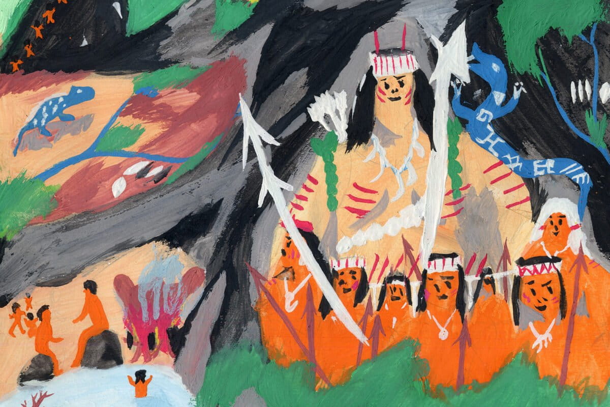
For more than two decades, field research by archaeological anthropologist Renzo Duin has documented densely saturated archaeological landscapes beneath forest canopies, usually classified as “untouched.”While illegal gold mining pollutes rivers with mercury and cyanide, mapping historical ecological sites in Suriname could leverage Indigenous guardianship to protect the forest’s rich biodiversity.Despite the nation’s high-profile pledge to permanently protect 90% of its forests, experts warn that neglecting the historical role of Indigenous stewardship leaves the ecosystem vulnerable to ongoing illegal deforestation. In 2004, archaeological anthropologist Renzo Duin joined an expedition into the mountainous tri-border area where Brazil, Suriname and Guyana meet alongside French botanists and ecologists. While the scientific team focused on mapping the biodiversity of what appeared to be untouched vegetation, Duin noticed that the ground told a very different story, rich with traces of pre-Columbian human occupation. “While they investigated what they perceived as pristine rainforest, I found the area dotted with fragments of pottery and other archaeological indications, including a site surrounded by a ditch,” Duin told Mongabay in a video call from The Hague, Netherlands. The evidence uncovered by Duin was one of many showing that the Amazon rainforest of Suriname and the Guianas region has been shaped and inhabited by people for millennia. Over the years, the researcher returned regularly to the region, making him one of the leading Amazon archaeologists, reshaping the knowledge about human occupation in the rainforest. “In the last three decades, archaeological knowledge of the Amazon has made a great stride forward in Brazil, Ecuador and Bolivia,” Duin said. “In Guyana, Suriname and French Guiana, the picture of the past has improved along the coast and major rivers. Yet, in the inland-uplands we have barely scratched the surface regarding the long-time histories of the Indigenous peoples.” Renzo Duin in the Tumuc-Humac Mountains. Image by © 2004, Renzo Duin /AMIK. As elsewhere in the Amazon, archaeological research in the region has unveiled a wealth of ancient rock art sites, stone tools, pottery and agricultural practices dating back thousands of years. A human presence in the rainforest, much older and widespread than previously thought, has challenged the long-dominant view of a pristine forest inhabited by small tribes of nomadic hunter-gatherers. However, this deep historical-ecological heritage is frequently overlooked in environmental and conservation policies in the region, especially in Suriname, where Duin has focused much of his work. Although the country prides itself on being the “greenest nation on the planet” and has pledged internationally to permanently protect 90% of its forests, this preservationist approach ignores the historic presence and stewardship of Indigenous peoples, according to Duin. Alongside the lack of recognition for Indigenous land rights, Suriname faces a chronic absence of preventive archaeology legislation to protect historical heritage against major development projects, illegal mining, and deforestation. Without integrating human history into environmental protection, the archaeologist argues, the country’s ecosystems remain vulnerable, and native populations continue to be excluded from conservation decisions concerning their own ancestrally managed territories. Officially registered archaeological sites in Suriname and nature parks, plotted on a DEM. Note how the known sites are mainly located along main rivers, roads, airfields, and most of Suriname remains archaeologically unexplored. Map generated by © 2026, Renzo Duin /AMIK. Recording oral history Duin obtained his doctorate from the University of Florida in the U.S., where professor of anthropology (specialized in archaeology) Michael Heckenberger was his Ph.D. advisor. Duin first traveled to French Guiana in 1996. Ever since, he has conducted numerous field trips lasting up to 11 months in the region between the Amazon River, the Orinoco River and the Atlantic Ocean. He first arrived for a series of ethno-archaeological projects along the Maroni River, which forms the border between Suriname and French Guiana, to study Indigenous architecture and settlement patterns. Yet, he soon realized that Indigenous life along the coast had been greatly altered by past colonial rule and modern developments. To better understand Indigenous architecture and settlement patterns, a local Indigenous Kalina man advised Duin to travel upstream to meet the Wayana people, who today number about 2,500. So he did. And he has continued to do so ever since. “When I first visited their Indigenous villages, I immediately saw they were, almost without exception, built on archaeological sites,” Duin said. “And the local inhabitants were very aware of that. I was not telling them anything new. Yet, most of these sites were not indicated on the national archaeological map, let alone researched.” While staying with the Wayana, Duin developed an interest in their oral history. He learned that the founding father of the Wayana Nation is Yapoto Kailawa, a hero with mythical qualities who killed and buried the giant man-eating caterpillar in the enigmatic Tumuc-Humac Mountains, which form the border between Brazil, Suriname and French Guiana. A watercolor by the Indigenous Wayana, Aimawale Opoya. In the AMIK-Archive. Painted on-site in the Tumuc-Humac mountains. Depiction of the Indigenous Wayana hero Kailawa and the foundation of the Wayana confederation in the Tumuc-Humac mountains after Europeans killed Indigenous Peoples and destroyed Indigenous villages, according to Wayana Social Memory. Image by © 2004, Renzo Duin /AMIK. A few years later, Duin had the chance to visit the tri-border of Brazil, Suriname and Guyana. Wayana families wished to show him the location and origin of their myths, legends and histories. Duin experienced that history, which is not something solely written in books. The landscape is engraved with it. Where the official maps indicate primary forests, Duin — often upon indication by his Indigenous travel companions — saw plenty of signs of past human occupation. As such, nature and culture are inseparably intertwined. While these initial findings seemingly back up the Wayana’s oral history, Duin is the first to acknowledge that the remote region requires a systematic archaeological survey, which, due to a lack of political will and funds, has not happened. Additional surveys conducted by Duin elsewhere in the Wayana area and beyond found densely saturated archaeological landscapes. Years of work with the Wayana, Kalina and other Indigenous and Maroon communities strengthened Duin’s belief that it was crucially important to record oral history, encourage intergenerational dialogue, and triangulate this local knowledge with archival sources and archaeological findings. It led him to co-found the International Center for Amazonian Indigenous Knowledge (AMIK), which strives to recognize Indigenous rights, including safeguarding Indigenous intangible cultural heritage, knowledge and livelihood. In collaboration with various Indigenous communities, AMIK has executed a range of mapping projects across the region to “ground-truth” historical, sacred or sensitive and other heritage sites mentioned in historical sources, oral histories and myths. Upper Maroni River, French Guiana, French National Park, Parc amazonien de Guyane. On the right bank is located a fortified hilltop site, well-known in Indigenous Wayana Social Memory. Image by © 2024, Renzo Duin /AMIK. Suriname’s lack of support In 2010, some Wayana living along the Maroni River asked Duin if he could extend his project to the other side of the Maroni River, where their grandparents used to live. As Duin’s permits had been granted by the French ministry for the French Guiana territory, he had to request permission from the authorities in Suriname to extend his participatory archaeological project. It was then that he first realized that the archaeological service of Suriname, as part of the Ministry of Education, Science and Culture (MEWC), was, by and large, dormant, according to him. And still is, he said. Between 1947 and 1981, archaeological research in Suriname was mainly coordinated from the Suriname Museum in Paramaribo, Duin said. “Due to the civil war from 1986 to 1992, archaeology came to a standstill in Suriname,” Duin said. “And it is essentially still standing still, due to a lack of funding for programmatic archaeological research and a lack of a policy issuing a directive for preventive archaeology.” French archaeologist Stephen Rostain, who long worked in French Guiana, agreed. According to him, the then “British” Guiana and Suriname, in archaeological terms, did quite well in the 1970s. “Unfortunately, after those countries’ independence, things took a turn for the worse,” Rostain told Mongabay. “French Guiana from the 1980s took a leading role in the region, thanks to the establishment of the Regional Archaeology Service and the introduction of preventive archaeology.” Small-scale miners work on the grounds of a gold mining concession operated by multinational joint venture Surgold, in Sipaliwini district, some 150 kilometers (93 miles) southeast of Suriname’s capital Paramaribo, November 2010. Nearby, rescuers worked to recover the bodies of unauthorized miners from a pit mine which collapsed the previous evening, killing at least seven. Image by AP Photo/Edward Troon. In 2013, Duin contributed to a draft proposal to revitalize archaeological research and policy, yet he says it hardly changed reality. Unlike French Guiana, Suriname still lacks legislation that requires investors to allocate funds for preventive archaeology in large infrastructure projects, such as dams, mines, roads, housing projects and agricultural development projects. “The 2002 Monumentenwet [Monuments Law] is the only law in Suriname that references archaeology,” archaeologist Cheryl White told Mongabay in a video call from the Faculty of Humanities at the Anton de Kom University of Suriname (AdeKUS). Yet, the law is limited in scope, as it is written within a context of historical monuments, she added. “It mostly applies to old city centers, like Paramaribo’s, and not to the archaeological sites that have been and might still be found elsewhere in the country.” Duin worked with White on a 2013 proposal on preventive archaeology for the MinOWC. Later, she helped prepare guidelines for land and water archaeology, comparing rules and regulations in different countries, and formulating a best practice policy for large earth-moving activities executed by, for example, mining companies. “It has been sitting on the desk of, I think, five directors of Culture and four ministers — I lost count,” White said. “The main reason is inconsistency. There is a constant change of leadership at the ministry, as a consequence of which preventive archaeology has never become a priority.” Map onto which are plotted the Indigenous villages in southeast Suriname, following the 1609 Fisher report. From the article: Lost ‘Townes’ of the Arawak in South-East Suriname. ARCHAEOLOGY AND ANTHROPOLOGY, Vol. 19 No. 2, 58-78. Map generated by © 2015, Renzo Duin /AMIK. Ancient practices Despite the lack of clear policy, archaeological evidence in Suriname has added significant milestones in the field. Stone projectile points found in the Sipaliwini Savanna in the far south of the country indicate a human presence dating back some 13,000 years. In 2000, hundreds of petroglyphs were discovered in the Werehpai cave complex some 400 kilometers (249 miles) south of Paramaribo. Carbon dating of charcoal found at the site dates back as far as 5,000 years. In the 1950s, Dutch engineer Hendrik Dost first identified raised fields and canals in the coastal region of northern Suriname. Known as the Hertenrits, the country’s biggest mound measures some 200 by 300 meters (656 by 984 feet). It was surrounded by a ditch to protect against seasonal flooding. Dost’s discoveries prompted Rostain to look for similar structures on the coast of French Guiana in the late 1980s. He famously found thousands. Meanwhile, American archaeologist Anna Roosevelt discovered large pre-Columbian corn plantations along the Amazon and Orinoco rivers in Venezuelan Guiana. That evidence helped shape a new understanding of the Amazon civilizations, challenging the scientific consensus that saw human presence in the rainforest as relatively recent and limited to small groups of hunter-gatherers, as the rainforest was supposed to be unable to support agriculture. One of the leading experts on this topic is Brazilian archaeologist Eduardo Neves, who has proposed leveraging this new archaeological knowledge to safeguard the rainforest by registering ancient sites as national monuments. He argues that this approach would not only protect the Amazon ecosystem but also allow local communities to remain on their ancestral lands, empowering them as the best line of defense for the forest. In the coastal plain of the Guianas and Suriname, archaeologists discovered a patchwork of raised settlements, fields and waterworks, breaking the old belief that the region consisted solely of slash-and-burn agriculture. Upper Maroni River, French Guiana, French National Park, Parc amazonien de Guyane. A metal pot and other cultural items were exposed during the burning of a slash-and-burn agricultural field. Indigenous Wayana Social Memory acknowledged the presence of a historical village on this site. Image by © 2022, Renzo Duin /AMIK. The obscure interior The image of the past of inland Suriname is less clear. However, in 1977 a railway was constructed from the Corantijn River, on the border with Guyana, to facilitate mining in the Bakhuis Mountains. Ten days of archaeological research found thick layers of human-altered, extremely fertile soil known as terra preta (dark earth) dating some 2,000 to 4,000 years — the oldest known agricultural practice in Suriname, Duin said. The pottery style, named Kaurikreek after the location it was found, is unique to Suriname. Across the river in Guyana, archaeological material linked to this agricultural complex dates back even further: Some 4,000 to 6,000 years. In 2012, Duin investigated another archaeological site with thick layers of dark earth and Kaurikreek-style pottery. Strongly indicating a second site of its kind in Suriname, it presented an opportunity to further research ancient agricultural practices. Yet, this hasn’t happened so far. Suriname’s apparent lack of interest may be related to the site’s location in an area that was part of the 30,000 hectares (74,132 acres) of so-called “primary forest” the Suriname government aimed to sell to a group of Mennonite families to plant soy. Last year, Mongabay published documents detailing the scheme, which was canceled following a wave of protests. Upper Maroni River, French Guiana, French National Park, Parc amazonien de Guyane. Indigenous Wayana team members conducting soil sampling in an archaeological test unit for soil chemical analysis, as part of the Participatory Archaeology Research Project directed by Dr. Renzo Duin/AMIK. Image by © 2024, Renzo Duin /AMIK. Lack of Indigenous rights Suriname prides itself on having an estimated 93% forest cover — 13.5% of which is protected. It is one of only three countries in the world that absorbs more carbon dioxide than it emits. At the 2025 Climate Week in New York in the U.S., Suriname made public the pledge to permanently protect 90% of its forests. The initiative was hailed by nature conservationists. “We understand and accept the immense responsibility of stewarding over 15 million of hectares [37 million acres] of tropical rainforest in a world that is seeing her forests fall day in and day out,” proclaimed Suriname President Jennifer Geerling-Simons at the time. “It is, of course, a great initiative,” Duin said. “But conservation alone is not enough. Large swaths of Suriname are protected, yet still suffer from illegal deforestation and gold mining. And riverine communities suffer from the ramifications, such as mercury, cyanide and Total Suspended Solids polluting rivers. Also, when protecting biodiversity, why not acknowledge the role Indigenous peoples played in creating such a rich biodiversity?” A recent report by Amazon Conservation states that illegal gold mining has impacted some 92,000 hectares (227,000 acres) of Suriname forest since 2001. The southeastern tri-border area, home to the Wamaya, is one of the country’s most affected, with mercury and arsenic levels far above the safety limit, according to the UOL news outlet. Giant river otters (Pteronura brasiliensis). Image by © paul10011993 via iNaturalist (CC BY-NC 4.0). Recently, mass fish deaths in the Saramacca River sparked criticism from local communities. The investigation carried out by the national environmental authorities pointed to cyanide or chemical pollution as a likely cause. To locals, however, the deaths reflected a deeper issue: The lack of involvement in processes that directly affect their living environment. Since 2016, the Directorate for Sustainable Indigenous Development (DDOI) at the Ministry for Regional Development and Sports has been tasked with improving the socio-economic position of Indigenous peoples in Suriname. Mongabay approached the DDOI several times asking about the current state of Indigenous land rights, yet never received a reply. According to the Amazon Conservation Team (ACT), Suriname is the only country in South America that has not recognized any Indigenous property rights. Nor has it ratified the ILO Convention 169, a legally binding treaty protecting the rights of Indigenous and traditional communities. The Inter-American Court of Human Rights (IACHR), to which Suriname is a signatory, has ruled three times in favor of Indigenous and Maroon (descendants of enslaved Africans who escaped from colonial plantations and established independent communities) communities in legal disputes with the Suriname state. The nation has so far failed to fully comply with the verdicts. Saramacca river, Suriname jungle, primary rain forest. Image by Jan Willem Broekema via Wikimedia Commons (CC BY-SA 2.0). Banner image: A watercolor by the Indigenous Wayana, Aimawale Opoya. In the AMIK-Archive. Painted on-site in the Tumuc-Humac mountains. Depiction of the Indigenous Wayana hero Kailawa and the foundation of the Wayana confederation in the Tumuc-Humac mountains after Europeans killed Indigenous Peoples and destroyed Indigenous villages, according to Wayana Social Memory. Image by © 2004, Renzo Duin /AMIK. New conservation model calls for protecting Amazon for its archaeological riches FEEDBACK: Use this form to send a message to the author of this post. If you want to post a public comment, you can do that at the bottom of the page. Credits Topics
Suriname’s rich archaeological history may hold keys to conservation
Full Article
Original Source
Read the full article at News →KhanList aggregates and links to publicly available news content. We do not host full articles from third-party sources. Always verify important information with original sources.