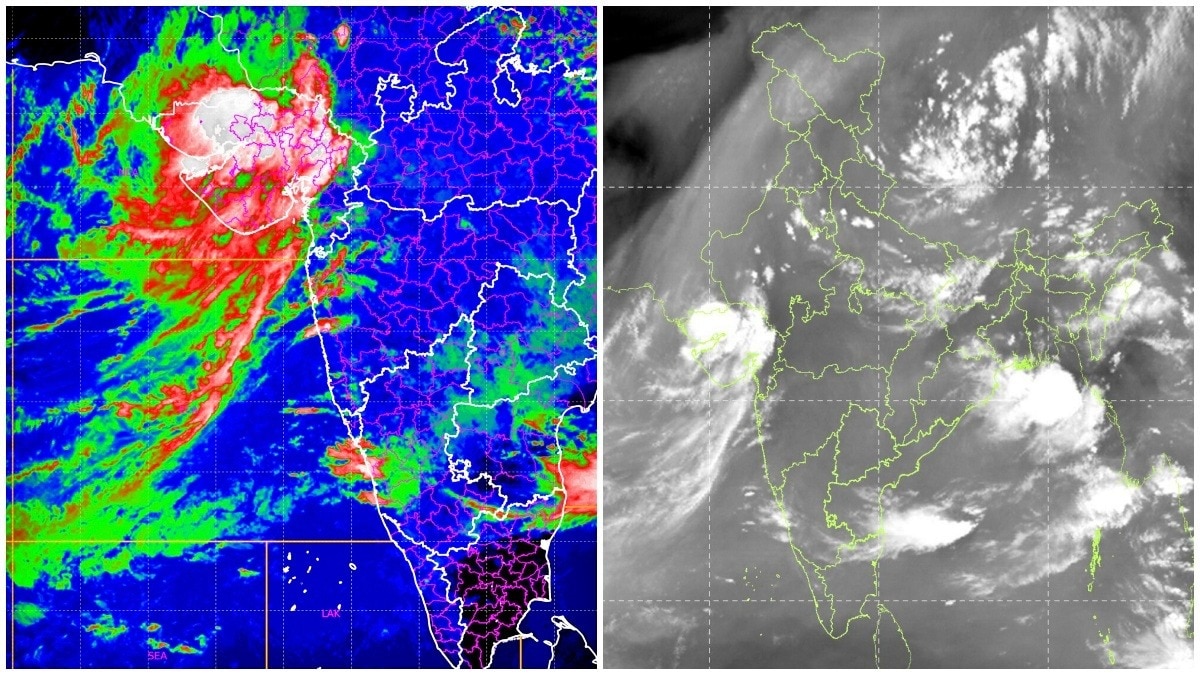
Fresh INSAT-3DR images show a vast Arabian Sea circulation pumping moisture into Gujarat. The slow-moving system has intensified rainfall and raised flood risks across several districts.The latest visible and thermal infrared imagery shows a vast cyclonic circulation. (Photo: IMD)Fresh satellite images from ISRO's INSAT-3DR weather satellite have captured a spectacular view of a massive atmospheric vortex spinning over the Arabian Sea, revealing the weather engine responsible for the torrential monsoon rains that have inundated large parts of Gujarat.The latest visible and thermal infrared imagery shows a vast cyclonic circulation stretching from the northeastern Arabian Sea into Gujarat, with tightly wound cloud bands continuously feeding moisture inland.The system has transformed the Arabian Sea into a conveyor belt of moisture, driving persistent thunderstorms and extreme rainfall across the state. The satellite imagery comes as Gujarat battles one of its most intense monsoon spells of the season. Ahmedabad alone recorded 294.6 mm of rainfall in the 24 hours ending 8:30 am on Friday, the highest July daily rainfall recorded this century and the fourth-highest daily total ever observed in the city.Follow Monsoon weather LiveWHAT IS THE ARABIAN SEA VORTEX? Meteorologists say the vortex is acting like a giant atmospheric pump. Counter-clockwise winds around the circulation are drawing enormous quantities of warm, moisture-laden air from the Arabian Sea into Gujarat, where the air is forced to rise rapidly, forming towering thunderclouds capable of producing torrential rain.The infrared satellite images reveal extremely cold cloud tops over northern and central Gujarat, an indication of deep convective storms extending high into the atmosphere.Such cloud structures are typically associated with intense thunderstorms, frequent lightning and exceptionally heavy rainfall.The weather system has also remained unusually slow-moving, allowing successive rain bands to pass repeatedly over the same districts.This phenomenon, often referred to as "training" thunderstorms, can dramatically increase rainfall totals and significantly raise the risk of flash floods and urban flooding.Forecast models indicate that the circulation will continue to influence weather over western India through the next 24 to 36 hours, with heavy to very heavy rainfall likely over parts of Gujarat, south Rajasthan and adjoining regions.The India Meteorological Department has maintained a red alert for several districts, cautioning residents about the possibility of flooding, waterlogging, traffic disruption and overflowing rivers.While the active monsoon has helped reduce seasonal rainfall deficits across several parts of the country, the Gujarat event highlights how a single, moisture-rich vortex over the Arabian Sea can unleash extraordinary rainfall in a short period.The Arabian Sea has become the driving force behind one of the strongest monsoon surges of the season, with the massive vortex continuing to funnel rain-bearing clouds over Gujarat before gradually weakening in the coming days.- EndsPublished By: Sibu Kumar TripathiPublished On: Jul 24, 2026 12:50 IST
Isro captures massive Arabian Sea vortex pumping monsoon rain over Gujarat
Full Article
Original Source
Read the full article at Indiatoday →KhanList aggregates and links to publicly available news content. We do not host full articles from third-party sources. Always verify important information with original sources.