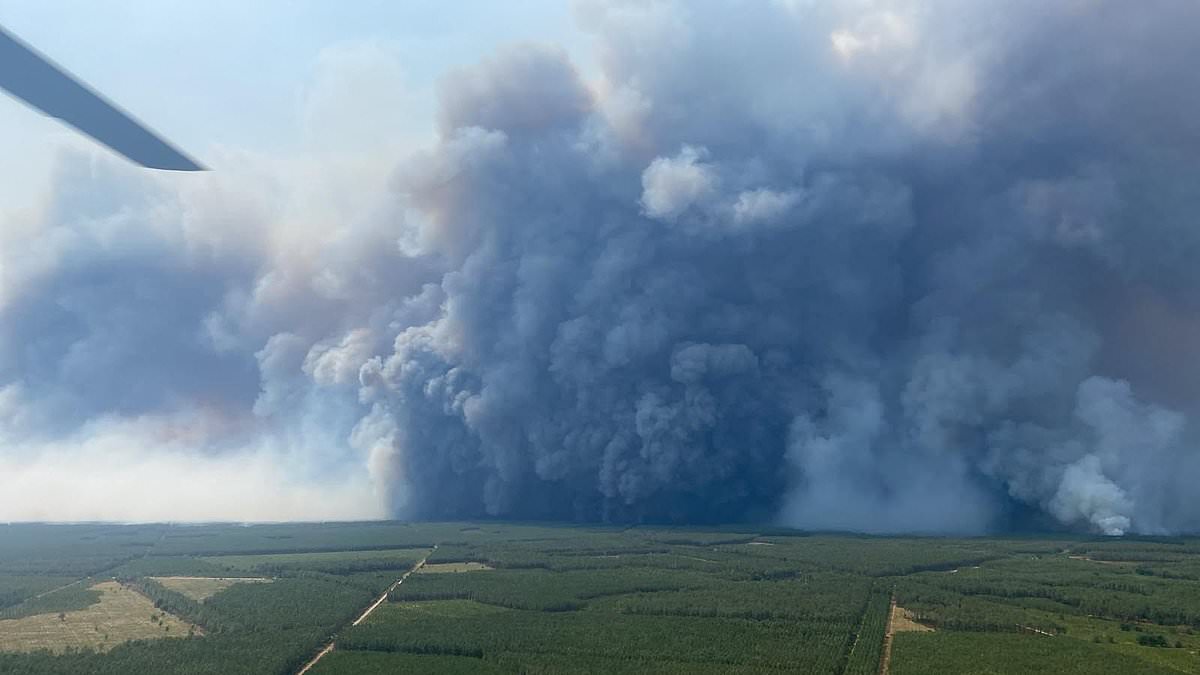
As apocalyptic fires rage across France and Spain, experts have warned that an extremely dangerous ‘fire cloud’ is supercharging the devastating inferno.More than 250,000 people have been evacuated as wildfires tear through southwest Europe, with wind and record-breaking heat fuelling the blaze.The fire has become so intense that it is now generating its own weather phenomenon, known as a pyrocumulonimbus.This towering cloud forms when an intense blaze pumps vast amounts of hot air, ash and smoke high into the atmosphere.As the plume rises, it cools and moisture condenses to form a giant 'fire cloud' which generates strong, erratic winds that feed the blaze below.Experts say stronger wind gusts can create more unpredictable fire patterns, making it more dangerous for firefighters battling the inferno on the ground.It can even produce lightning, sparking fresh wildfires many miles away.One has already formed over Bordeaux, where flames are consuming forests and destroying villages, amid warnings the worst could still be to come. Experts have warned that an extremely dangerous ‘firecloud’ is supercharging the devastating inferno. Pictured: A giant cloud created by a large fire as seen from a fire fighter helicopter over the village of Saumos, France,on SaturdayUntil now, these clouds have only really been seen in wildfire-prone Australia and North America. This is the first time the phenomenon has ever been documented in France. They can be so devastating that NASA has called them the ‘fire-breathing dragon of clouds’.Lieutenant Colonel Eric Brocardi, from the National Firefighters Federation of France (FNSPF), explained: ‘The rise in ground temperature at the heart of the blaze is so extreme that the intense heat surges upward in a column, meeting cooler air masses at the top.‘This contact creates a pyrocumulonimbus - or fire cloud - though unfortunately one devoid of moisture.‘This smoke cloud generates its own weather system, causing anything in its path to spontaneously combust.‘Lightning forms within the cloud, striking the embers on the ground and further fuelling the fire...it produces a low, rumbling sound.‘While this type of fire occurs regularly in Canada and Australia, it is unprecedented in France.’He explained that the situation is now ‘completely unpredictable’ because the winds are constantly shifting, causing the fire to spread ‘in every direction’. More than 2,500 firefighters are battling a 20km-wide front of flames that are spreading across southwestern France How a fire cloud forms An intense wildfire generates enormous heat: As a blaze burns it releases huge amounts of heat, causing hot air, ash and smoke to rise rapidly into the sky.The rising plume acts like a giant chimney: The hot air climbs thousands of feet into the atmosphere, carrying smoke, soot and moisture with it.A towering cloud begins to form: As the plume rises, it cools and the moisture condenses into a huge cloud known as a pyrocumulonimbus, or ‘fire cloud’.The cloud creates its own weather: The fire cloud can generate powerful updrafts and downdrafts, producing strong, erratic winds that feed the blaze below.Lightning can spark new fires: Like an ordinary thunderstorm, a fire cloud can produce lightning – sometimes igniting fresh wildfires many miles away.The blaze becomes even harder to control: The combination of fierce winds, flying embers and new lightning strikes can cause the fire to spread rapidly and behave unpredictably, making it far more dangerous for firefighters. ‘We don't know how the blaze will spread; the fire front is constantly shifting,’ Mr Brocardi added.‘We cannot fight it directly. It's a David-versus-Goliath scenario: The idea is that, at some point, we'll find a weak spot and strike there.‘Salvation will come either from the sky - in the form of rain, though it would need to pour heavily for three days - or by finding a way to steer the fire toward a place where it will die out on its own. The sea, for example.’He said the firefighters have reached a point of ‘operational impossibility’ that means they have been forced to accept a strategic retreat.‘The situation on the ground is defensive rather than offensive,’ he said.‘It is a warlike scenario where we are under constant bombardment and must get everyone to safety.’There are fears that 38°C heat in southern France will continue to fan the flames of the terrifying blaze, with the inferno already stretching for kilometres.Convoys of tractors were spotted driving through towns on Sunday towing huge water tankers in an effort to reinforce the fire crews heroically battling the blaze, which has injured 75 and killed two. Convoys of tractors carrying huge water tankers on their way to reinforce fire crews on the frontline of the blazeIt comes as France enters its fourth heatwave this summer, spreading panic as wildfires across the country destroy thousands of tons of crops – leading to fears of vegetable shortages on supermarket shelves.French president Emmanuel Macron has called a Monday morning crisis meeting with his cabinet to discuss the emergency.Scientists say climate change is making such extreme weather events more frequent and intense.Coming at the height of the summer holiday season, the fires were fuelled by woodland which had dried out during successive heatwaves and lack of rain since May.
What is a fire cloud? Scientists blame little-known weather phenomenon for supercharging the wildfires blazing across France and Spain - as they warn the worst could be yet to come
Full Article
Original Source
Read the full article at Dailymail →KhanList aggregates and links to publicly available news content. We do not host full articles from third-party sources. Always verify important information with original sources.