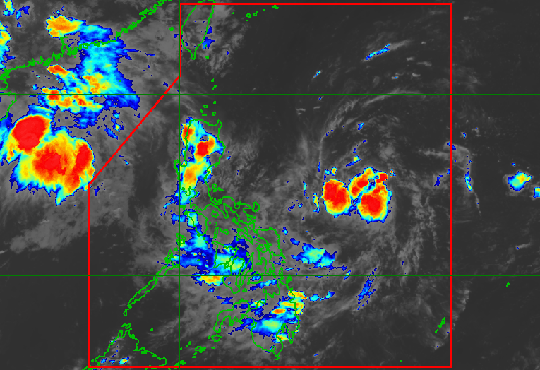
LPA. Satellite image of the low pressure area as of July 31, 2026, 8 pm. PAGASA The low pressure area is 865 kilometers east of southeastern Luzon as of 8 pm on Friday, July 31 MANILA, Philippines – The low pressure area (LPA) that formed outside the Philippine Area of Responsibility last Wednesday, July 29, entered PAR on Friday, July 31. As of 8 pm on Friday, the LPA was located 865 kilometers east of southeastern Luzon. The Philippine Atmospheric, Geophysical, and Astronomical Services Administration (PAGASA) said the LPA has a low chance of developing into a tropical depression within 24 hours. While the LPA is still far from land, its trough or extension has been causing scattered rain and thunderstorms in the Visayas, Mindanao, Bicol, Quezon, Laguna, and Marinduque. PAGASA advised the affected areas to remain on alert for flash floods and landslides. The rest of Luzon, not affected by the trough of the LPA, is seeing generally fair weather, with just localized thunderstorms. The other LPA that PAGASA was monitoring in the final week of July already dissipated over the West Philippine Sea on Thursday, July 30. It formed last Tuesday, July 28, then crossed Southern Luzon on Wednesday. The Philippines is currently experiencing a monsoon break, with no rain from the southwest monsoon or habagat. Monsoon breaks, which can last for days or even weeks, are normal during the rainy season. But the southwest monsoon may return next week, as it is expected to be enhanced by the tropical cyclone with the international name Dolphin, which is currently a super typhoon around 4,000 kilometers away from the Philippines. Based on initial forecasts, Dolphin itself appears unlikely to make landfall in the country, but the monsoon rain could trigger floods and landslides. The Philippines saw four tropical cyclones in July: Tropical Depression Henry, Super Typhoon Inday (Bavi), Tropical Storm Josie (Haishen), and Typhoon Kiyapo (Noul). PAGASA said two to four tropical cyclones could develop within or enter PAR in August. – Rappler.com How does this make you feel? Loading
Visayas, Mindanao, parts of Southern Luzon rainy due to trough of LPA
Full Article
Original Source
Read the full article at Rappler →KhanList aggregates and links to publicly available news content. We do not host full articles from third-party sources. Always verify important information with original sources.