
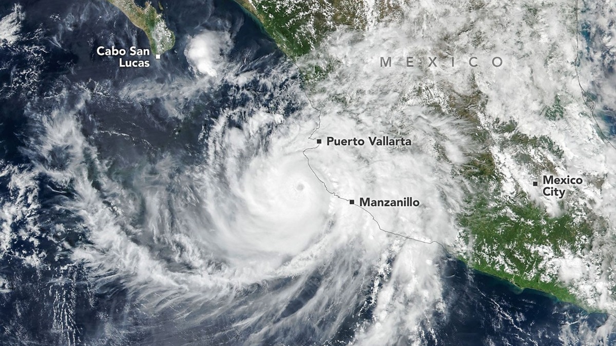
Satellite images captured Hurricane Simon nearing Mexico and sending gravity waves into the upper atmosphere. The storm brought flooding and mudslide risks as its future path remained uncertain.Hurricane Simon churns off Mexico’s Pacific coast in this image acquired with the VIIRS. (Photo: Nasa)New Delhi,Oct 14, 2026 11:47 ISTA powerful Hurricane Simon, which intensified into a Category 4 storm with winds reaching 250 kmph, was captured by satellites as it swept close to Mexico’s Pacific coast, bringing heavy rainfall, flooding and the risk of landslides to coastal and mountainous regions.The storm passed offshore on October 11, 2026, with its eye located about 50 km from the coast between Manzanillo and Puerto Vallarta.An image captured by the Visible Infrared Imaging Radiometer Suite (VIIRS) aboard NASA’s Suomi NPP satellite around 2:30 pm local time showed the massive storm system approaching the Mexican coastline.According to the US National Hurricane Center (NHC), Simon’s sustained winds had reached approximately 210 kmph when the satellite acquired the image, with the hurricane’s inner core brushing against the coast. The mountainous terrain of the Sierra Madre appeared to weaken the storm somewhat and reduce the extent of its wind field. Atmospheric gravity waves generated by Hurricane Simon are visible via mesospheric airglow in this nighttime image acquired with the VIIRS. (Photo: Nasa) Despite the weakening, Simon brought heavy rain and flooding to coastal areas, including the port city of Manzanillo, while raising concerns about mudslides in mountainous regions.HURRICANE’S EFFECTS REACH EARTH’S UPPER ATMOSPHERESatellites also detected the hurricane’s influence far above the storm itself. A nighttime image captured by VIIRS aboard the NOAA-21 satellite on October 11 revealed atmospheric gravity waves radiating outward from the hurricane. These waves appeared as ripples in the faint natural glow emitted by gases in the upper atmosphere, known as airglow.NASA explained that the waves form when heat released during the condensation of water vapour near a hurricane’s eyewall fuels powerful thunderstorms. The resulting towering cumulonimbus clouds generate strong upward air currents that can send waves into the stratosphere and mesosphere. Hurricane Simon's forecast. (Photo: Windy) The phenomenon is not always visible because winds in the upper atmosphere can dissipate the waves before they reach the mesosphere. Minimal moonlight on the night of the observation helped the satellite detect the faint airglow patterns.HURRICANE SIMON’S PATH REMAINS UNCERTAINBy October 13, Simon had weakened to a Category 2 hurricane, with maximum sustained winds of around 175 kmph. The NHC placed it approximately 90 km west-southwest of Cabo Corrientes in Jalisco state.Forecasters said the storm’s future path and intensity remained highly uncertain. Simon was expected to move north towards the Gulf of California, with a possible landfall in Sinaloa state later in the week.Meteorologists warned that the storm’s slow movement could prolong rainfall and increase flooding risks, while large swells threatened dangerous coastal conditions along parts of southwestern and west-central Mexico.- Ends
Satellite captures Hurricane Simon creating gravity waves from space
Full Article
Original Source
Read the full article at Indiatoday →KhanList aggregates and links to publicly available news content. We do not host full articles from third-party sources. Always verify important information with original sources.