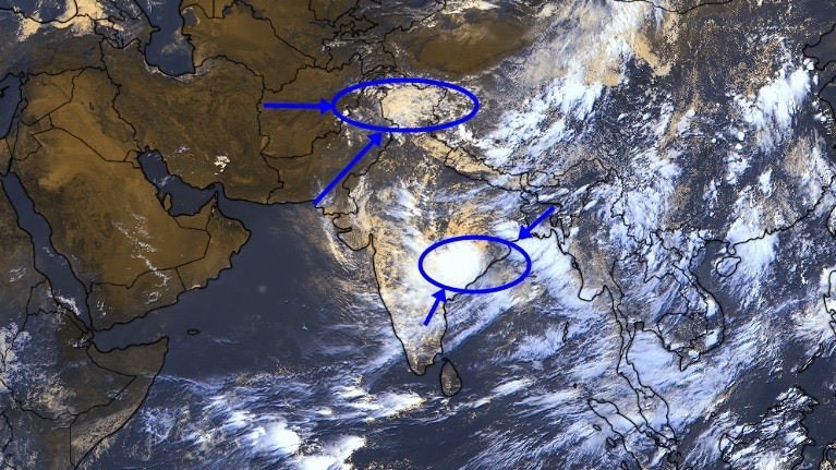
North India is gearing up for a fresh spell of heavy rain, thunderstorms and gusty winds as two powerful weather systems come together over the region.A deep depression that has already drenched eastern and central India is now moving westward, where it is set to interact with a fresh western disturbance over the Himalayas. Vehicles ply on a road amid heavy rain. (Photo: PTI) Isolated heavy spells and thunderstorms are expected to sweep large parts of North India over the next few days, according to the India Meteorological Department (IMD).The system that has been driving rain for days is still carrying abundant moisture inland, but this time it has another weather system boosting its impact. A satellite image of the moving Deep Depression. (Photo: IMD) DEEP DEPRESSION CONTINUES JOURNEYA deep depression is a well-developed low-pressure weather system that pulls vast amounts of moisture from the sea, often resulting in heavy rainfall and strong winds.The current system formed over the northwest Bay of Bengal before intensifying and crossing the West Bengal-Odisha coast near Digha between July 27 and 28. A man protects himself with a plastic sheet amid heavy rain. (Photo: PTI) Since then, it has tracked inland across north Odisha, Jharkhand and central Chhattisgarh, unleashing extremely heavy rainfall across these regions.On July 29, around 1 pm, the IMD said that the system had moved westwards at about 15 kmph over the past six hours and is centred over central Chhattisgarh and adjoining north interior Odisha, near Raigarh.It is expected to continue moving nearly westwards across Chhattisgarh and into east Madhya Pradesh over the next 24 hours. A satellite image shows the weather systems over the Indian subcontinent. (Photo: Windy) Although the deep depression is gradually weakening over land, it continues to pump large amounts of moisture into the monsoon flow, providing the fuel needed for widespread rainfall further north.WESTERN DISTURBANCE TO FUEL RAINFALLAdding to the mix is a fresh western disturbance, currently active over the western Himalayan region in the form of an upper-air trough.Western disturbances are weather systems that originate over the Mediterranean region and travel eastward, bringing additional moisture to northwest India. They frequently trigger rain or snowfall over the Himalayas and adjoining plains. People push an auto-rickshaw through a waterlogged underpass. (Photo: PTI) As this western disturbance interacts with the inland deep depression and the active monsoon trough, rainfall activity is expected to intensify across north India over the next three to four days.The IMD has forecast fairly widespread rainfall accompanied by thunderstorms, lightning and gusty winds over Delhi-NCR, Punjab, Haryana, Himachal Pradesh, Uttarakhand, Uttar Pradesh and parts of Rajasthan through early August.Furthermore, Chhattisgarh is likely to witness heavy to very heavy rainfall in several places, with isolated extremely heavy rainfall on July 29. Â People wade through a waterlogged road following heavy rain. (Photo: PTI) East and West Madhya Pradesh, Vidarbha and Telangana are also expected to receive heavy to very heavy rainfall over the next two to 2-3 days, while isolated heavy rainfall is forecast over west Uttar Pradesh.Apart from providing relief from warm and humid conditions, this active spell could also help reduce the seasonal rainfall deficit that has persisted across several parts of North India after an uneven start to the monsoon. A weather map shows rain forecast across the Indian subcontinent. (Photo: Windy) AN UNEVEN MONSOON IMPROVINGIndia's southwest monsoon, which delivers nearly 70-80% of the country's annual rainfall between June and September, stumbled at the start of the season.June ended as one of the driest in more than a century, leaving the country with a rainfall deficit of nearly 40%.Rainfall activity picked up sharply in July as successive low-pressure systems revived the monsoon, helping the country record near-normal rainfall for the month and significantly narrowing the monthly shortfall. Students cross a road amid heavy rain. (Photo: PTI) Despite this recovery, India's cumulative seasonal rainfall remains below normal as of late July.The deficit is still pronounced across East and Northeast India, as well as parts of the southern peninsula, while several regions in central and western India have managed to erase their deficits and, in some places, even record surplus rainfall.- EndsPublished On: Jul 29, 2026 15:07 IST
Rain, thunderstorms to rise in North India as two weather systems crash
Full Article
Original Source
Read the full article at Indiatoday →KhanList aggregates and links to publicly available news content. We do not host full articles from third-party sources. Always verify important information with original sources.