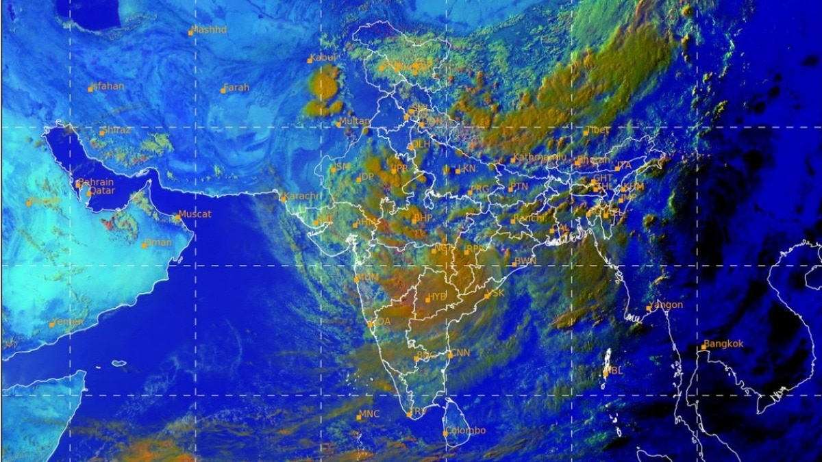
A deep depression moving inland from Odisha is set to interact with a Western Disturbance over the western Himalayas. The overlap could intensify rain across north and central India and raise flooding and transport risks.Satellite imagery showed the two large weather systems operating simultaneously. (Photo: IMD)India is set to witness an intense spell of monsoon activity over the next four days as a deep depression moving across central India is expected to interact with an active Western Disturbance over the western Himalayas, raising the possibility of widespread heavy rainfall, thunderstorms, local flooding and traffic disruptions across several states.Satellite imagery on Tuesday showed the two large weather systems operating simultaneously. While the deep depression that crossed the Odisha coast has moved inland and is carrying enormous amounts of moisture into central India, a Western Disturbance is currently affecting Jammu and Kashmir.Weather experts say moisture and wind flow between the two systems could significantly enhance rainfall over north and central India. The interaction is expected to trigger moderate to heavy rain across Madhya Pradesh, Chhattisgarh, Maharashtra and parts of Telangana as the deep depression tracks west-northwestwards.At the same time, rainfall is likely to intensify over Punjab, Haryana, Delhi-NCR, Uttar Pradesh, Uttarakhand, Himachal Pradesh and Jammu and Kashmir during the next three to four days. Meteorologists caution that when a moisture-laden monsoon system interacts with a Western Disturbance, atmospheric instability increases, often leading to widespread thunderstorms, intense downpours and prolonged rainfall episodes.Such interactions have historically produced some of the season's heaviest rain events across northern India.Urban areas may experience waterlogging, traffic congestion and delays in road, rail and air transport. Low-lying regions and flood-prone districts could also witness a rise in river levels, while hilly states remain vulnerable to landslides and flash floods.Authorities have advised residents in affected regions to remain alert, particularly in areas prone to flooding or unstable slopes. Commuters are likely to face slow-moving traffic during peak rainfall periods, especially in major cities.The coming 72 to 96 hours will be crucial as forecasters closely monitor how the Western Disturbance and the deep depression evolve. Even a slight change in the track or timing of either system could alter rainfall intensity and distribution.For now, weather agencies expect monsoon activity to remain vigorous through the week, bringing much-needed rain to some regions but also increasing the risk of weather-related disruptions.- EndsPublished By: Sibu Kumar TripathiPublished On: Jul 30, 2026 07:00 IST
Monsoon to turn vigorous for next four days. Expect heavy rain, flash flooding
Full Article
Original Source
Read the full article at Indiatoday →KhanList aggregates and links to publicly available news content. We do not host full articles from third-party sources. Always verify important information with original sources.