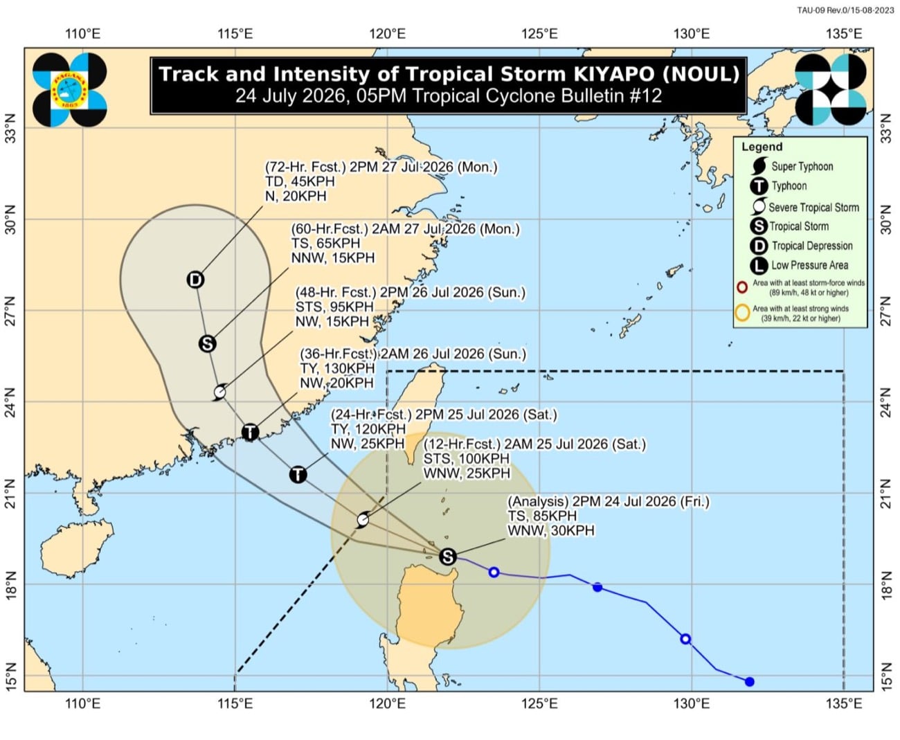
Track and intensity forecast of Tropical Storm Kiyapo as of 5 p.m. on Friday, July 25 (Photo by Pagasa) MANILA, Philippines — Tropical Storm Kiyapo (international name: Noul) gained strength after making landfall over Camiguin Island in Cagayan on Friday afternoon, the state weather bureau said. In its 5 p.m. weather bulletin, the Philippine Atmospheric, Geophysical, and Astronomical Services Administration (Pagasa) said that Kiyapo was last located over the coastal waters of Calayan Islands, Calayan, Cagayan as of 4 p.m. It made landfall over the vicinity at 2:15 p.m. on Friday. It gained strength as it was now carrying a maximum wind speed of 85 kilometers per hour (kph) and gustiness of up to 115 kph, from the 2 p.m.’s bulletin of wind speed of 75 kph and gustiness of up to 90 kph. It slightly accelerated as it was moving west-northwestward at 30 kph. Article continues after this advertisement Pagasa also said that the Tropical Cyclone Wind Signal (TCWS) No. 2 remained hoisted over the following areas in Northern Luzon: Batanes Northern portion of Cagayan (Santa Ana, Gonzaga, Santa Teresita, Camalaniugan, Aparri, Ballesteros, Abulug, Pamplona, Sanchez-Mira, Claveria, Santa Praxedes, Buguey, Allacapan, Lal-Lo, Gattaran, Baggao, Lasam) including Babuyan Islands Northern portion of Apayao (Luna, Santa Marcela, Calanasan, Pudtol, Flora) Northern portion of Ilocos Norte (Pagudpud, Dumalneg, Adams, Bangui, Burgos, Vintar) It then warned of “minor to moderate threat to life and property” as wind speeds range from 62 to 88 kph. READ: Tuguegarao City, 24 towns suspend face-to-face classes due to Kiyapo Meanwhile, TCWS No. 1 was raised in the following areas, with potential of minimal to minor threat to life and property (wind speeds ranging from 39 to 61 kph): Rest of mainland Cagayan Isabela Quirino Nueva Vizcaya Rest of Apayao Abra Kalinga Mountain Province Ifugao Benguet Rest of Ilocos Norte Ilocos Sur La Union Northern and central portions of Aurora (Dilasag, Casiguran, Dinalungan, Dipaculao) Pagasa also said that the southwest monsoon or habagat and Kiyapo will bring strong to gale-force gusts over these areas: Friday, July 24: most of the country Saturday, July 25: Most of Luzon, Western Visayas, Negros Island Region, Cebu, Northern Samar, Zamboanga del Norte, Sultan Kudarat, and Davao Oriental Sunday, July 26: Batanes, Cagayan, Ilocos Region, Zambales, Bataan, Quezon, and Mimaropa (Mindoro, Marinduque, Romblon, and Palawan) The bureau added that Kiyapo will continue to intensify while moving over Extreme Northern Luzon and may develop into a severe tropical storm while or after passing Babuyan Islands. /mr Your subscription could not be saved. Please try again. Your subscription has been successful.
Kiyapo gains strength after making landfall over Camiguin Islands
Full Article
Original Source
Read the full article at Newsinfo →KhanList aggregates and links to publicly available news content. We do not host full articles from third-party sources. Always verify important information with original sources.