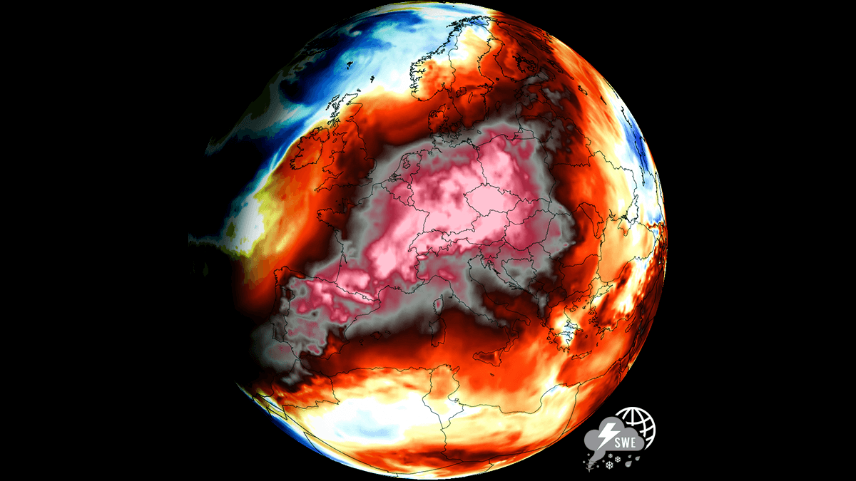
As July transitions into August, the European continent is bracing for yet another intense heatwave and potentially historic escalation in the excessive heat. Driven by a textbook atmospheric Omega block, a monstrous, long-lasting fourth heatwave of the season will surge northward from North Africa, with a relentless Heat Dome locking over Western and Central Europe and the Mediterranean. High-resolution global ensemble weather models are hinting at potentially historic mid- to upper-air thermal anomalies tracking well into the 99th percentile and setting the stage for yet another brutal, record-challenging heatwave and extreme temperatures for the summer of 2026. The heat will expand across most of Europe by the end of July, and continue into August. Primarily, the new Heat Dome centers over the Iberian Peninsula and France, where the late-July into early-August peak will see widespread air temperatures surging past the 40 °C mark easily, possibly reaching levels up to 45 °C in some areas. As the core of the ridge drifts eastward, its impact will spread over Central Europe, dragging punishing 40+ °C readings from western Germany to the Benelux, Italy, Hungary and most of the northern Balkan countries. Reinforced by a synoptic setup that pumps an exceptionally hot, dry air mass straight from the Sahara Desert into the central portions of Europe, all atmospheric layers could potentially challenge their historic records as the Heat Dome intensifies. Some weather models hint at 25 to nearly 28 °C reached at the 850 mbar level. Compounding the atmospheric furnace is escalating ecological disasters, as tinder-dry forests in southern France and Spain are under extreme wildfire risk. And these conditions will also spread across Central Europe as the dry heat expands over the following weekend. With relative humidity plunging well below 20 percent, explosive wildfire conditions are in place. Although the air mass will be dry with the upcoming prolonged heatwave, the nighttime relief will be virtually nonexistent, with overnight lows remaining in the mid- to upper 20s in places, compounding physiological stress for millions of residents and crops in many regions. The long-lasting heatwave with temperatures 35 to 40+ °C for days will also rapidly worsen the heat stress and existing drought conditions. The driving force behind this pattern is similar to the one Europe faced in late June and mid-July, but this time the Heat Dome will be positioned more across the central parts. And much more intense. With a strengthening upper-level ridge building out of Northwest Africa and expanding a major warm plume across most of continental Europe. Before we dig into the details about the pattern evolution, lets examine what is the main driver behind these extensive warm waves and heatwaves in general. What is a Heat Dome? When significant, record-breaking heatwaves occurred in Europe, the United States, and Canada in the past, the Heat Dome was a contributing factor. The heat dome is usually the dominant feature of summer weather patterns on both continents. We refer to this phenomenon as a heat dome when extremely high temperatures develop. Here’s how it works and why understanding it on a broader scale is essential. The upper-level ridge pattern, or very warm air mass in the higher altitudes, also known as the Upper High (or blocking High), usually forms the heat dome. This weather pattern brings high, and sometimes record-breaking, temperatures to the region below. This term is used when a broad area of high-pressure air parks over a large portion of the continent. If the event is remarkably stable and extreme, it usually lasts several days or weeks. The heat dome works like a lid on a pot. The dome traps warm air at all levels beneath it, with layers sinking toward the ground. As a result, the air mass becomes anomalously warm at the lowest elevations and extremely hot near the surface. How does a heat dome impact the life underneath? Excessive heat in heat domes can significantly impact human health and be dangerous to particularly vulnerable populations, such as elderly individuals, children, and those with pre-existing health conditions that can be worsened by extreme heat. Due to prolonged exposure to high temperatures, construction workers, farmers, and other long-hour outdoor workers are at increased risk of heat-related illnesses. People living in poverty are also more susceptible to the fatalities of heat domes, as their houses are often built with heat-trapping surfaces such as concrete and asbestos. Heat exhaustion occurs with prolonged exposure to high temperatures. It leads to dehydration, dizziness, and, in more severe cases, heat exhaustion can progress to heat stroke. High relative humidity during a heatwave can also significantly affect the body. For this reason, we use the Heat Index to represent the perceived feel of scorching-hot temperatures and high humidity. It illustrates the natural relationship between temperature and humidity. When the air mass has a temperature around +35 °C, humidity below 60 percent is much less challenging than when the humidity is very high, e.g., above 80 %. Thus, the actual feel temperature would be near 50 degrees Celsius. Beneath these staggering meteorological statistics lies an even more grim danger. Extreme heat is a silent killer, and this current dome has already turned lethal, claiming lives across France and Spain within its first days. The danger is magnified by suffocating so-called “tropical nights” where temperatures don’t drop by 24 °C, denying the human body its vital window to cool down. Because centralized residential air conditioning is rare across Europe, emergency rooms are bracing for an onslaught of life-threatening heat stroke. Heat waves have also been associated with increased rates of heart attacks, strokes, and respiratory illnesses. Our additional article, Health risks during a heatwave and sweltering hot weather, provides further details on the health risks. Yet another massive, potentially historic Heat Dome is set to expand over Europe as July ends The end of July is shaping up to deliver yet another powerful upper-level ridge, with a major Heat Dome across the heart of Europe. It is forecast to engulf most of the continent with excessive heat from Iberia to France, Germany, and the Baltic region, as well as over Central Europe and the Mediterranean, where the peak summer season has tens of millions of residents on vacation. The forecast pattern that establishes over the continent for the remainder of July and extends into early August 2026 resembles a classic Omega Block, with a High in the core of Europe and two deep lows on each side. One over the North Atlantic and the other over Russia. The surface response of the powerful High raises sea-level pressure over most of Europe, while lower pressure persists across the North Atlantic, associated with the deep low aloft. This supports a generally weak-wind environment until the end of July. However, towards the weekend, when August arrives, the surface High shifts its center from Eastern Europe more towards Germany, Denmark, and the Baltic region, while lower pressure also establishes over the Mediterranean and southwestern Europe. This means that lower layers of the atmosphere will establish a more east-northeast flow, bringing much drier air masses from the continent towards the Mediterranean. This usually delivers extreme, record-challenging heat as the air masses adiabatically warm up even further due to the downslope Foehn wind effect. The medium-range ensemble guidance (ECMWF and GFS) indicates that the 500 mbar geopotential heights could reach near-record levels for the end of July, climbing exceptionally high as the upper-level subtropical air mass expands. These anomalous upper-level heights, paired with soaring 850 mbar temperatures, represent a highly anomalous tropospheric setup. With sinking air (compression and warming at the surface), 850 mbar temperatures could reach nearly 30 °C over the Mediterranean. The sinking air within the heat dome also translates into rising pressure beneath, thereby developing a surface high-pressure system. In addition, this pattern also creates extreme to explosive wildfire conditions. Wildfire risks will become a serious concern and could worsen the ongoing events in Spain and France, and ignite new wildfires across the Mediterranean and the western Balkan countries. This powerful blocking High will remain parked over Europe for nearly two weeks, resulting in locally historic heatwave with temperatures above 40 °C in many countries. The only near-normal temperatures will be in NW Europe with maritime air masses in place over northern Scandinavia, the northern British Isles, and the far northern Atlantic. Temperatures at the 850 mbar level are forecast to push into the 24-28 °C across a broad part of Europe, which is particularly extreme and usually happens with the most intense heatwaves. Through mid-week and Thursday, the most anomalous low-level temperatures will be from Iberia to France, Germany and southern Scandinavia. Then, towards the weekend, the Heat Dome moves more southeast and the worst heat is forecast for central Europe, the Balkans and the Mediterranean. Such arid conditions will allow temperatures to climb extremely high. Peak daytime highs are forecast to push well above 40 °C for many countries, challenging historic all-time records The heatwave rapidly intensifies by mid-week as the ridge expands and parks its axis over west-central Europe. France On Wednesday, GFS forecasts that 40-43 °C will expand extreme heat into western and central France. The rest of France should expect 34 to 39 °C peak afternoon temperatures. Mid-week will be the hottest for France this week, as then the dome aloft shifts more east-northeast and the most extreme warmth moves away. By the weekend, temperatures will remain in the mid to upper-30s, but may push above the 40 °C mark only in the deep south regions. Spain & Portugal Spain and Portugal will not be spared from the reinforced heatwave either; the hottest air mass is forecast to develop late this week. Especially Friday will be brutally hot across southern Portugal into south-central Spain. The peak temperatures will reach 42 to 46 °C in the most heat-prone lowlands due to extremely low humidity. It will also remain hot over the weekend, but a few degrees lower peaks as maritime air mass from the Atlantic gradually engulfs northwestern portions of the Iberian peninsula. Thus sending more humid and cooler air masses into Portugal and northern Spain. Italy, Mediterranean and the Balkan peninsula With this heatwave, the hottest air mass of the season will develop over Central Europe, the Balkans and the Mediterranean from mid-week into the following weekend. This is forecast right at the peak of the Mediterranean tourist season, with tens of millions on vacation these weeks. The excessive, record-challenging heat will engulf north-central Italy and the Panonian plains into 40-43 °C for multiple days after Thursday. The rest of the Balkan Peninsula will also gradually warm up late this week, but temperatures should remain in the upper 30s. The 40s are expected to spread over the Po Valley and Tuscany in Italy, some lowlands in Slovenia, eastern Croatia, northern Bosnia & Herzegovina, north-central Serbia, most of Hungary and western Romania over the weekend. The general more northeasterly dry flow, with an extremely hot air mass over the weekend, will push temperatures into the range of historic all-time high records and likely surpass them in places. History will be rewritten locally. Nighttime temperatures will also be high once more windy days happen, and winds will also rapidly increase the wildfire danger over the Balkans and Italy. UK, Wales and Ireland This time, the position of the Heat Dome over Europe will only bring a short-term heatwave into the British Isles. Tuesday and Wednesday are forecast to be the hottest days, and later this week temperatures will be lower under the influence of a maritime air mass from the west. However, the heat will be quite strong, especially on Wednesday, where peak afternoon temperatures are forecast to reach 33-36 °C across south-central England, mid to upper 20s over Ireland and northern UK. Germany, Benelux to Poland and Czech Republic Similar to far Western Europe, the most excessive heat over the Benelux and Germany will be over this part of Europe for about three days. It will also be hot on the other days through the end of July and over the weekend, but the most intense heat will be on Wednesday and Thursday. Peak temperatures will reach into the upper 30s to possibly 40-41 °C in some regions on both days. This is forecast for the Benelux on Wednesday and Germany on Thursday. Temperatures will also rapidly push into the mid- to upper-30s over Austria, the Czech Republic, Slovakia, and Poland after Thursday and remain similar into the weekend. Eastern Europe By the weekend, as the Heat Dome expands into Eastern Europe and the Balkans, an extremely hot air mass will also spread into Ukraine, Moldova, and Western Russia. Temperatures will climb to near 40 °C on Sunday in the west and continue from 38-41 °C through mid next week. *****Note that this heatwave, combined with moderately strong and very dry winds, will further support an ongoing extreme fire risk over southwestern Europe and also support an additional wildfire threat over Italy, the Alpine region, and the Balkans. New wildfires may ignite and spread rapidly in these conditions, as very low relative humidity and stronger winds become supportive of explosive and uncontrollable wildfires. We will be monitoring the ongoing development of the 4th heatwave this summer, with the potential further expansion of the Heat Dome towards mid-August. We will update the forecasts accordingly as the situation evolves over the next weekend. Stay tuned. Wxcharts, PivotalWeather, and Wetterzentrale provided images used in this article. See also: Super El Niño Forecast Pushes Toward Record Strength as Winter 2026/2027 Signals Emerge
Europe’s Heat Dome Furnace Returns: Brutal 40+ °C Record Heatwave Builds Into August
Full Article
Original Source
Read the full article at Severe-weather →KhanList aggregates and links to publicly available news content. We do not host full articles from third-party sources. Always verify important information with original sources.