
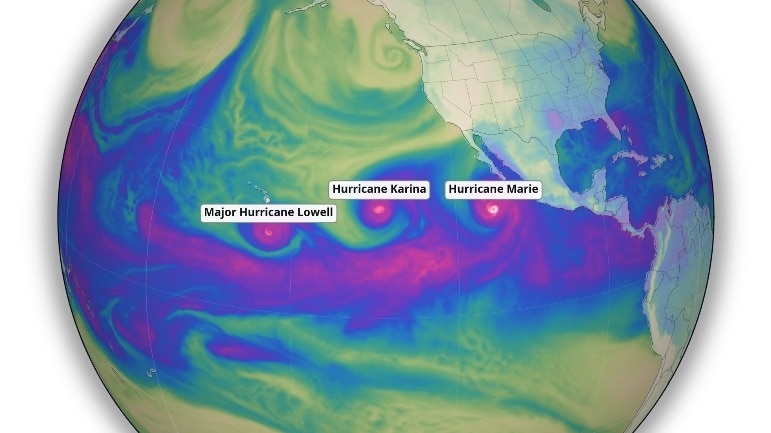
The Pacific is unusually busy at the start of September, with two major hurricanes and a tropical storm spinning simultaneously across the eastern and central North Pacific.On September 1, Hurricane Karina and Hurricane Lowell were both major hurricanes, while Tropical Storm Marie was developing farther east, off southwestern Mexico.The US National Hurricane Center was tracking all three systems, with none posing an immediate direct land threat at the time.The burst of activity comes as a strengthening El Nino is taking shape across the tropical Pacific. Thanks in part to El Nino, the east Pacific is an absolute Hurricane machine.#Marie is unlikely to hit California, but it's proximity will bring tropical moisture to the southwest U.S. this weekend, possibly with some monsoonal showers to boot. #cawx pic.twitter.com/P0Pj7ydrXV— Sean Macaday (@MacadayWX) September 1, 2026 But the climate pattern is best understood as one factor influencing the broader environment for storms, rather than the force directly creating each hurricane.TWO HURRICANES AND A STORMKarina was located well west-southwest of Mexico's Baja California Peninsula and was moving west over open water. On September 1, it had maximum sustained winds of about 220 kmph.Lowell, meanwhile, was several hundred kilometres southeast of Hawaii and had also reached major-hurricane strength, with maximum sustained winds of about 210 kmph.Both storms were expected to remain over the Pacific, although forecasters were monitoring their movements and potential effects on coastal areas. A satellite image shows the storms and hurricanes forming in the Pacific Ocean. (Photo: Windy) Marie, which formed on September 1, was a tropical storm, not a hurricane, and was located southwest of Mexico and had maximum sustained winds of about 100 kmph.Forecasters were watching its development and track as it moved over the Pacific.EL NINO SETS THE STAGEEl Nino is a natural climate pattern in which the central and eastern tropical Pacific become warmer than usual.That warmer ocean can provide more energy for thunderstorms that eventually organise into tropical cyclones.But warm water alone is not enough.Vertical wind shear, which is the change in wind speed or direction with height, can disrupt developing storms.El Nino can alter these upper-level winds and, in the eastern Pacific, generally create conditions that are more favourable for tropical cyclone development.Other factors, including ocean heat beneath the surface, atmospheric moisture, local wind patterns and the storms' surroundings, also determine whether a system forms and how strong it becomes.So the current Pacific activity cannot be solely attributed to El Nino.Instead, the developing climate pattern is tilting the background conditions in a direction that can favour tropical cyclone activity.NOAA said in August that El Nino was strengthening, with a greater than 90% chance of a very strong event during the Northern Hemisphere autumn and winter of 2026-27. A patch of a warm Pacific Ocean is captured by a satellite image. (Photo: Windy) Other factors, particularly conditions in the Indian Ocean, called the Indian Ocean Dipole, can strengthen or weaken its influence.The World Meteorological Organisation (WMO) has also warned that the developing El Nino could drive significant shifts in rainfall patterns around the world.For now, the Pacific's stormy spell is best seen as one visible expression of a rapidly strengthening El Nino, setting the stage up for a potentially active and stormy year ahead.- EndsPublished On: Sep 2, 2026 13:42 IST
El Nino's rage: Pacific Ocean churns twin hurricanes and a storm
Full Article
Original Source
Read the full article at Indiatoday →KhanList aggregates and links to publicly available news content. We do not host full articles from third-party sources. Always verify important information with original sources.