
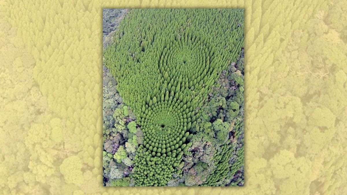
The trees were deliberately arranged in circles to test the effects of different planting densities. Published Sept. 12, 2026 Claim: Photograph authentically shows a circular "experimental forestry" project in Japan. Rating: ContextAlthough the photograph recirculated in 2026, it dates back to at least December 2018. In September 2026, an aerial photograph of trees growing in concentric circles spread online, with social media users claiming they were part of a decades-old forestry experiment in Japan. "In 1973 Japan planted trees in concentric circles as part of an experiment in forestry spacing. This is what they look like today from above," one Reddit post (archived) captioned the photograph. (Reddit u/Impressive_East_) That image and other photographs showing the same formations have circulated online for years, appearing on platforms such as Instagram, 9GAG, Facebook, Pinterest and X. In short, the photograph was real, and the claim about the forest was also accurate. It showed two experimental plots of Japanese cedar near Nichinan, a city in Miyazaki Prefecture on the island of Kyushu. According to the Miyazaki Southern Forest Management Office, the experiment was established in fiscal year 1973 to study how different planting densities affected tree growth and wood quality. As such, we have rated this claim as true. The photograph circulating in 2026 was not new — we traced it to at least December 2018. The same forest has attracted attention before. We previously investigated similar photographs of the experimental plots in September 2024. One of the images circulating at the time was also available in The Associated Press' image archive. Origin of the photograph The photograph first gained attention when Japanese news outlet Sankei News published it in a story about the forest. (www.sankei.com) The outlet credited the image to Miyazaki Southern Forest Management Office, a regional office of Japan's Forestry Agency. Its caption (translated from Japanese via Google Translate) read, "A circular pattern visible in the mountains of Nichinan City, Miyazaki Prefecture." The image later appeared in numerous social media posts and articles. What the photograph shows The photographs circulating online show Japanese cedar trees arranged in two groups of concentric circles in a national forest near Nichinan, in Miyazaki Prefecture. An AP caption describing the forest said the trees in the outer ring were approximately 20 meters (66 feet) tall, about 5 meters (16 feet) taller than those near the center. The circular forest was also discoverable on Google Maps and Google Earth, as the Miyazaki Southern Forest Management Office gave its location as 31°43'50.0"N, 131°23'05.0"E. According to the office, the experiment was linked to changes in the local timber industry. Obi cedar was planted sparsely in the area for shipbuilding timber, but demand later shifted toward wood for general construction. Researchers created the experiment to study how different planting densities affected tree growth and wood quality. It was established in fiscal 1973, with the cedar seedlings planted in March 1974. The trees were arranged in concentric circles at different distances from one another, creating planting densities of about 377 to 10,027 trees per hectare. Seen from above, this produced the circular pattern that earned the site the nickname "mystery circles." Later surveys showed that planting density affected the trees' size and growth. A 2011 study concluded that around 2,000 to 2,800 trees per hectare was suitable for lower-cost forestry. The experiment's final report, completed in fiscal year 2023, concluded that planting densities of 1,500 trees per hectare or fewer could be effective in terms of financial returns and afforestation costs. For further reading, in January 2015 we investigated whether a law in Japan makes it illegal for citizens to be fat. Sources "FACT CHECK: Is It Illegal to Be Fat in Japan?" Snopes.Com, https://www.snopes.com/fact-check/the-metabo-law/. Accessed 9 Sept. 2026.Fukuchi, Shinsuke, et al. "Analysis of the Planting Density Toward Low-Cost Forestry: A Result From the Experimental Plots of Obi-Sugi Planting Density.." Journal of the Japanese Forest Society, vol. 93, no. 6, 2011, pp. 303–308, https://www.jstage.jst.go.jp/article/jjfs/93/6/93_6_303/_article/-char/en, 10.4005/jjfs.93.303. Accessed 9 Sept. 2026."Newsroom." Ap.Org, 2026, https://newsroom.ap.org/editorial-photos-videos/detail?itemid=a057b47244664e1fb9120e485145eb98&mediatype=photo. Accessed 9 Sept. 2026.SANKEI DIGITAL INC. "試験林に「ミステリーサークル」? 宮崎県日南市." 産経フォト, 2018, https://www.sankei.com/photo/daily/news/181216/dly1812160004-n1.html. Accessed 9 Sept. 2026.Wrona, Aleksandra. "Photo Shows Circular 'Experimental Forestry' Project in Japan?" Snopes, Snopes.com, 4 Oct. 2024, https://www.snopes.com/fact-check/japan-experimental-forestry/. Accessed 9 Sept. 2026."お知らせ:九州森林管理局." Maff.Go.Jp, 2016, https://www.rinya.maff.go.jp/kyusyu/miyazakinanbu/sub1.html. Accessed 9 Sept. 2026.---. Maff.Go.Jp, 2016, https://www.rinya.maff.go.jp/kyusyu/miyazakinanbu/sub1.html. Accessed 9 Sept. 2026.---. Maff.Go.Jp, 2016, https://www.rinya.maff.go.jp/kyusyu/miyazakinanbu/sub1.html. Accessed 9 Sept. 2026."サイトマップ:九州森林管理局." Maff.Go.Jp, 2026, https://www.rinya.maff.go.jp/kyusyu/use/sitemap.html#annai. Accessed 9 Sept. 2026.ヒバ林の復元を行っている人工林 ヒバの伏条更新 「パイロットフォレスト」 「ヒバ林の復元」 青森ヒバの天然林は日本三大美林の一つに数 えられ、かつては津軽半島及び下北半島に豊富に 生育していました。ヒバは写真のように巨木に生 育し、ヒバ材は古くから神社仏閣や住宅などに利 用されてきました。しかしながら、ヒバは生長が 遅く、木材として利用できるまで 100 ~ 200 年 を要するため、ヒバ林の伐採後には、成長の早い スギやカラマツなどが植栽されたことから、現 在、ヒバの資源量は十分とは言えません。 そこで、東北森林管理局では、平成 27 年度か ら津軽半島及び下北半島においてヒバ林を復元 する取組を行っています。 平成 29 年度には、ヒバ林の周辺に植栽された スギ等の人工林のうち、天然更新したヒバの稚樹 が旺盛に生育している箇所を含む9箇所 29Ha の 区域で、実際にスギ等の伐採を行い、人工林をヒ バ林へ誘導するための手法の検証を行っていま す。将来的には、津軽半島及び下北半島に設定し た 15 万 Ha の「ヒバ林復元推進エリア」におい て青森ヒバ林を復元することを目指しています。 ※伏条更新とは、地面に接した枝から根が出て稚樹が発生すること。 季節毎にお送りする「各地の森林から」 。今回は各地で様々な試行錯誤を繰り返し、多様な森林の 造成を行ってきた国有林の中にあって、技術開発の歴史の中から生まれた、各地の特徴的な森林づ くりをご紹介します。 各 地 の 森 林 か ら パイロットフォレストの紅葉 湿原部分に生息するタンチョウ ヒバの実生 ヒバ天然林の林内の様子 パイロットフォレストは、北海道の東部、霧 き り た っ ぷ 多布湿原と釧路湿原の間に位置する 別 べ か ん べ う し 寒辺牛湿原の周辺に広がるカラマツ人工林を主体とする、 約1万ヘクタールの森林です。 この場所は、開拓の火入れによる失火等のため、毎年のように発生した山火事により森 林が消滅し、かつては「死の荒野」とまで呼ばれた広大な原野でした。 このような中、昭和 30 ~ 40 年代に、この地に森林を蘇らせるための大規模な森林造 成が開始されました。湿原周辺での植林作業は、湿原に車を通すための浮橋の設置や広大 な原野に繁茂するササの処理など、困難を極めました。 このような苦労の末、約 60 年を経過した現在、パイロットフォレストは年間約1万㎥ 以上の木材を生産するまでに資源として充実し、湿原部分はタンチョウが生息するなど、 野生生物の生息環境としても役割を果たしています。 森林造成のためのササ処理の様子 (昭和35年)."宮崎南部森林管理署:九州森林管理局." Maff.Go.Jp, 2026, https://www.rinya.maff.go.jp/kyusyu/miyazakinanbu/index.html. Accessed 9 Sept. 2026.Google.Com, 2026, https://earth.google.com/web/search/31%c2%b043%2750%2e0%22N+131%c2%b023%2705%2e0%22E/@31.73038346. Accessed 9 Sept. 2026. By Aleksandra Wrona Aleksandra Wrona is a reporting fellow for Snopes, based in the Warsaw, Poland, area. Article Tags
Does photo show experimental circular forest in Japan?
Full Article
Original Source
Read the full article at Snopes →KhanList aggregates and links to publicly available news content. We do not host full articles from third-party sources. Always verify important information with original sources.