
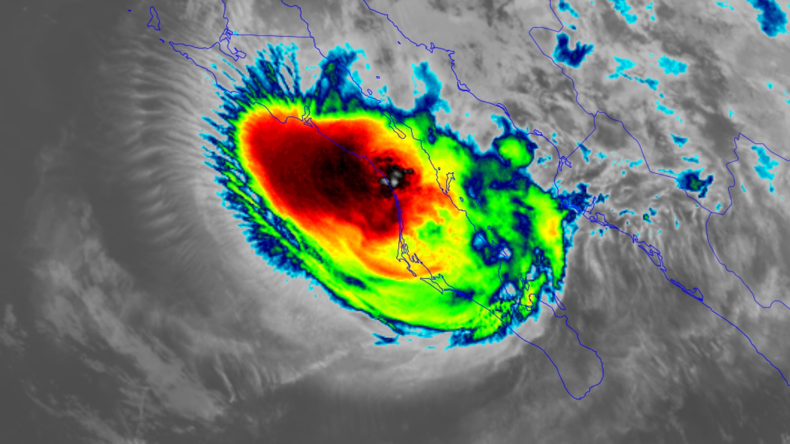
Infrared satellite image of Hurricane Polo at 0450Z (12:50 a.m. EDT) Tuesday, September 29, 2026. (Image credit: RAMMB/CIRA/CSU) Hurricane Polo stormed onto the coast of Mexico’s Baja California Sur on Monday night local time, making landfall just south of Las Barrancas at around 11 p.m. MST (2 a.m. EDT Tuesday) as a high-end Category 2 storm with top sustained winds of 110 mph (175 km/h) and a central pressure of 965 mb. Polo was tied as the fourth-strongest hurricane on record to make landfall on the Baja Peninsula, and is one of only 10 Cat 2 or stronger hurricanes to hit the peninsula since record-keeping began in 1949 (Fig. 1). Figure 1. All Category 2 and stronger hurricanes since 1949 to hit the Baja California peninsula of Mexico. (Image credit: NOAA Hurricane History) Satellite imagery showed Polo becoming more disheveled in the several hours prior to landfall, as intrusions of dry air, increasing wind shear, and the increasing influence of rugged terrain all took their toll. Toda la furia del huracán Polo sobre Puerto Adolfo López Mateos esta noche en el municipio de #Comondú.El centro del huracán a punto de entrar a tierra cerca de Las Barrancas.📹: Karla Mayoral. pic.twitter.com/f3MiR9pOY2— Clima Sudcaliforniano (@ClimaSudCalifor) September 29, 2026 After crossing the Baja California peninsula, Polo reemerged over the toasty waters of the Gulf of California, but by that point the hurricane’s structure was too compromised to take full advantage of the unusual warmth there. Polo made landfall shortly after 11 a.m. EDT Tuesday just east of Guaymas with winds that had dropped to minimal hurricane strength of 75 mph (120 km/h) at 11 a.m. EDT. Hurricane Polo is one of the most incredible tropical cyclones in modern history: – Went from a tropical storm to Category 5 in ~21 hours– Reached Category 5 intensity three separate times – Second-most intense eastern Pacific hurricane on record (892 mb) – Forecast to… pic.twitter.com/4oxUaUr15T— Colin McCarthy (@US_Stormwatch) September 29, 2026 The two landfalls brought an end to Polo’s remarkable journey as a hurricane – but the story of Polo’s influence on North America was just beginning. Pacific tropical moisture wrapping into a storm over the southwest US will continue a multi-day heavy rainfall event this week that will extend into the Midwest & southern Plains.Considerable flash flooding is possible across portions of New Mexico and west Texas today through Wednesday. weather.gov— National Weather Service (@nws.noaa.gov) 2026-09-29T15:52:37.447Z A midweek deluge will affect a broad corridor along the path of ex-Polo By late Tuesday, Polo is predicted to be a tropical or post-tropical depression approaching far west Texas and southern New Mexico on a continued northeasterly track. Polo’s large expanse of rich moisture will be hauled into the U.S. Southwest and Great Plains by the upper-level low that’s been steering Polo northeastward. Together with residual moisture from ex-Hurricane Odalys, and increasing low-level inflow from the Gulf of Mexico, the stage will be set for several days of widespread heavy rain, with pockets of torrential rainfall and localized flash flooding. The National Weather Service is predicting a swath of 2-5 inches of rain from Arizona and New Mexico northeastward along the path of Hurricane Polo’s remnants. Additional heavy rains of 3-7 inches are predicted over much of Texas into Oklahoma from an associated moist flow of air from the Gulf of Mexico. One particular area of concern for flooding is southern New Mexico, which has been reeling after multiple flash-flood events in recent weeks. The National Weather Service has placed most of the state and adjoining areas in their “Moderate” risk area for excessive rain (level 4 out of 5 risk) for Tuesday (see the embedded NWS post above). Figure 2. Predicted precipitation for the 5-day period ending at 8 a.m. EDT Sunday, Oct. 4. The National Weather Service is predicting a swath of 2-5″ from Arizona and New Mexico northeastward along the path of Hurricane Polo’s remnants. Additional heavy rains of 3-7″ are predicted over much of Texas into Oklahoma fromf an associated moist flow of air from the Gulf of Mexico. (Image credit: NWS) The widespread rainfall may come in the nick of time to help salvage what’s been a grim water year (Oct. 1 – Sept. 30) for some folks, but others could get left out. At the weather-and-climate research hub of Boulder, Colorado, the water-year total through Monday of 10.65 inches is only about half of the long-term average (1991-2020) and the lowest in 36 years of recordkeeping at the current observing site. Almost 2 inches of rain would need to fall by Wednesday evening to put 2025–26 ahead of 2001–02 (12.42 inches). Leading models have been in stark disagreement on whether Boulder will lie just outside or just inside the northwest edge of this week’s corridor of heavy rain, but it’s quite possible Boulder will get only scant amounts while southeast Colorado gets deluged. Across portions of 33 of the 48 contiguous U.S. states, over eight inches of rain is needed in just one month to alleviate long-term drought conditions (Fig. 3), so Polo’s rains on their own will not end the drought. The situation is particularly dire in Texas, where 9-19 inches are needed, and in Oklahoma, where 9-23 inches are needed. However, if the 2026-27 El Niño is true to form, the odds will be high for above-average precipitation later this fall and winter across the southern tier of states. Figure 3. Amount of precipitation needed in one month to end long-term drought conditions. (Image credit: NOAA) Elsewhere in the tropics There were still several tropical cyclones rolling across the Northern Hemisphere on Tuesday morning – including weak Tropical Storm Hanna and Tropical Depression Fay in the Atlantic, and Hurricane Nolo and Tropical Storm Rachel in the Pacific – but no direct landfall threats are expected through at least the rest of the week. Irene Sans contributed to this post. Republish our articles for free, online or in print, under a Creative Commons license. Bob Henson is a meteorologist and journalist based in Boulder, Colorado. He has written on weather and climate for the National Center for Atmospheric Research, Weather Underground, and many freelance... More by Bob Henson Jeff Masters, Ph.D., worked as a hurricane scientist with the NOAA Hurricane Hunters from 1986-1990. After a near-fatal flight into category 5 Hurricane Hugo, he left the Hurricane Hunters to pursue a... More by Jeff Masters
After two landfalls in Mexico, Hurricane Polo’s rainmaking journey has just begun
Full Article
Original Source
Read the full article at Yaleclimateconnections →KhanList aggregates and links to publicly available news content. We do not host full articles from third-party sources. Always verify important information with original sources.