
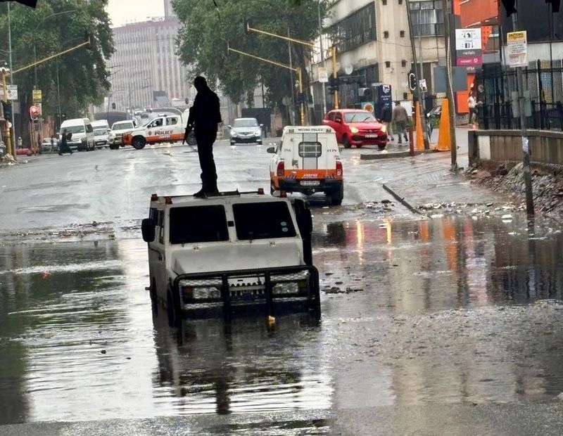
Severe thunderstorms brought heavy rain, strong winds and falling temperatures to parts of Gauteng, Free State and North West on Friday, 4 September, with weather-related hazards continuing into the weekend.The storms caused road closures in Johannesburg and damaged homes and infrastructure in parts of North West and Northern Cape.Storms and heavy rain continued into Saturday evening across the central and northeastern parts of the country, with Orange Level 5 and Yellow Level 4 warnings in place for affected areas.Warnings remained in place on Sunday morning, including a Yellow Level 4 warning for severe thunderstorms over the country’s eastern areas and an Orange Level 6 warning for the extreme northeastern parts of the country. Conditions are expected to improve on Monday.By Sunday afternoon, localised flooding had been reported at the intersection of Siemert Road and Currey Street in Doornfontein, where several vehicles became submerged and stuck in high water.Johannesburg Metro Police Department (JPMD) spokesperson Superintendent Xolani Fihla said officers were on the scene managing traffic, assisting stranded motorists and diverting vehicles away from the flooding.“If you encounter submerged roads or high standing water, turn around immediately,” Fihla said.Flooding at Siemert Road and Currey Street in Doornfontein, Johannesburg, on Sunday, 6 September. Several vehicles were reported to have become submerged in the water. (Photo: Supplied / JMPD) Motorists have been urged to avoid the area where possible, drive below the speed limit, maintain a safe following distance and keep their headlights on.The severe weather has been driven by an intense cut-off low-pressure system moving across the country. The system has drawn in tropical moisture, increasing the risk of localised flash flooding, damaging winds, hail and excessive lightning.Johannesburg weather damageOn Saturday, 5 September, a tree fell onto a JMPD vehicle in Witpoortjie.The JMPD also reported road closures in several parts of Johannesburg, including Cooper and Beryl streets in Cyrildene, Beatrice and Princess avenues in Windsor and Smit Street and 11th Avenue at the M1 on- and off-ramps.Fihla urged motorists and pedestrians to exercise extreme caution on the roads and provided alternative routes for motorists.Johannesburg Emergency Management Services spokesperson Robert Mulaudzi said specialised water rescue units and disaster monitoring teams had been placed on high alert across Gauteng because of slippery roads and rising water levels. Some roads in Johannesburg showed damage as heavy rain continued over the weekend. (Photo:Lubabalo Lesolle / Gallo Images) Damage to homes and schools in North WestSeveral homes were damaged over the weekend in two villages more than 70km outside Mahikeng.In Setlagole, strong winds damaged several residents’ homes, with some roofs blown off. Heavy rainfall caused further damage inside some houses.Speaking to the SABC on Saturday, North West Cooperative Governance and Traditional Affairs spokesperson Lerato Gambu said infrastructure in other parts of the province had also been severely damaged, including one learning centre and two primary schools.Eskom also reported power-supply interruptions in several parts of the province.The North West Provincial Disaster Management Centre has activated its coordinating structures across all district municipalities to aid the deployment of resources in response to localised flooding.Weather warnings in Northern Cape Parts of the Northern Cape were also affected by the severe weather.Some residents in the Sol Plaatje Municipality reported that the roofs had blown off their homes, while heavy rainfall caused further damage to household items.Authorities continue to monitor conditions as severe weather warnings remain in place.Severe weather to continue, warns SAWSCommuters try to avoid gushing water in Johannesburg after heavy rainfall. (Photo: Felix Dlangamandla / Netwerk24 / Gallo Images) Speaking to Daily Maverick, SAWS forecaster Lehlohonolo Thobela said partly cloudy and cold to cool conditions were expected across much of the central and eastern parts of the country on Sunday and Monday, with scattered to widespread showers and thunderstorms expected over Gauteng, KwaZulu-Natal, Free State, Mpumalanga, Limpopo, North West and the eastern parts of Northern Cape.“Severe thunderstorm warnings are in place for these areas for today and tomorrow,” Thobela said.Thobela said conditions were expected to start improving from Tuesday, with thunderstorms becoming isolated over Mpumalanga, Gauteng, KwaZulu-Natal and Limpopo. By Wednesday, no precipitation was expected over the central and eastern parts of the country, he said. DM
Water-logged: Severe storms batter Gauteng, North West and Northern Cape — roads closed, homes damaged
Full Article
Original Source
Read the full article at Dailymaverick →KhanList aggregates and links to publicly available news content. We do not host full articles from third-party sources. Always verify important information with original sources.