
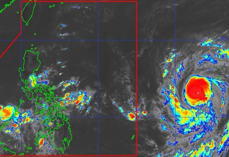
CHAMPI. Satellite image of Super Typhoon Champi outside the Philippine Area of Responsibility as of October 18, 2026, 10:30 am. PAGASA As of Sunday morning, October 18, Super Typhoon Champi is located 2,090 kilometers east of southeastern Luzon, still outside the Philippine Area of Responsibility Champi is expected to enter the Philippine Area of Responsibility as a super typhoon on Tuesday, October 20. While landfall in the Philippines appears less likely, Champi may still affect parts of the country, especially extreme Northern Luzon. This is AI-generated. Read the article for full context. Report any errors. MANILA, Philippines – A tropical cyclone with the international name Champi is expected to enter the Philippine Area of Responsibility (PAR) on Tuesday, October 20. Champi had intensified from a typhoon into a super typhoon as of 2 am on Sunday, October 18, and it is projected to enter PAR as a super typhoon. The Philippine Atmospheric, Geophysical, and Astronomical Services Administration (PAGASA) said in an advisory that Champi was located 2,090 kilometers east of southeastern Luzon as of 10 am on Sunday. The super typhoon is moving west at 25 kilometers per hour (km/h), while over the sea near the United States island territory of Guam. Champi did not make landfall in Guam, but still lashed the island with heavy rain and damaging winds during its closest point of approach in the early hours of Sunday, according to Guam Homeland Security. Guam is just two hours ahead of Manila. So far, Champi has maximum sustained winds of 185 km/h — the minimum threshold for classification as a super typhoon by PAGASA — and gustiness of up to 230 km/h. The weather bureau sees Champi strengthening further and possibly reaching a peak intensity of 205 km/h before its entry into PAR, but it may start gradually weakening on Tuesday. Once it enters PAR on Tuesday morning or afternoon, Champi will be given the local name Rosal. It would be the Philippines’ 18th tropical cyclone for 2026, and the first for October. Champi only has a slim chance of making landfall in the Philippines, as it is more likely to head for Taiwan. Taiwan, located above the northernmost province of Batanes, is within PAR. Although landfall is less likely in the country, PAGASA warned the public that Champi may still bring heavy rain to extreme Northern Luzon, or the Batanes-Babuyan Islands area. The weather bureau might also raise tropical cyclone wind signals for the northern and eastern portions of Northern Luzon and even parts of Bicol as early as Monday evening, October 19, or by Tuesday morning, since winds from Champi could reach these areas. The highest wind signal may be Signal No. 3 or 4. PAGASA added that most parts of Luzon and the Visayas, as well as portions of Mindanao, are likely to experience gusty conditions beginning Tuesday or Wednesday, October 21. Also on Tuesday, moderate to rough waters are expected in the northern and eastern seaboards of Luzon and the eastern seaboards of the Visayas and Mindanao. Starting Wednesday, very rough, high, or very high waters may affect the northern and eastern seaboards of Luzon. ALSO ON RAPPLER Part 1: No kids, no apologies: Why Filipino women are opting out of motherhood | Part 2: As Asia grays, can an aging Philippines avoid its neighbors’ fate? How world No. 1 Anna Leigh Waters balances life and pickleball [Vantage Point] When a paycheck runs out before payday For now, the intertropical convergence zone (ITCZ) and the easterlies are the weather systems affecting the country on Sunday. The ITCZ is a belt near the equator where the trade winds of the Northern Hemisphere and the Southern Hemisphere meet, while the easterlies are warm winds from the Pacific Ocean. The ITCZ is causing scattered rain and thunderstorms in the Zamboanga Peninsula, Basilan, Lanao del Sur, Lanao del Norte, Misamis Occidental, and Palawan, as well as isolated rain showers or thunderstorms in the rest of the Bangsamoro Autonomous Region in Muslim Mindanao and Soccsksargen. Meanwhile, the easterlies are bringing scattered rain and thunderstorms to Quezon and Camarines Norte, and isolated rain showers or thunderstorms to the rest of the country. The Philippines is currently in a transition period to the northeast monsoon or amihan, following the end of the southwest monsoon or habagat, which was announced last October 5. The northeast monsoon typically brings surges of cold temperatures, but the upcoming amihan period could be warmer as the existing strong El Niño in the tropical Pacific Ocean is predicted to become very strong in the fourth quarter of 2026. – Rappler.com How does this make you feel? Loading
Super Typhoon Champi to enter PAR on October 20
Full Article
Original Source
Read the full article at Rappler →KhanList aggregates and links to publicly available news content. We do not host full articles from third-party sources. Always verify important information with original sources.