
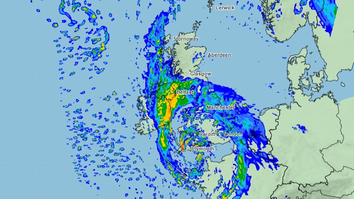
Families heading to the south coast for October half-term could face a washout with the first named storm of the season set to hit Britain. Storm Austen - officially named by the Met Office on Tuesday morning - is forecast to arrive on Thursday night and will bring 'strong winds and heavy rain'.A yellow weather warning for 'severe' wind has been put in place from Friday morning covering large parts of the south-east, south-west and Wales, though the entirety of the country is expected to be hit by rainfall. Gusts at speeds of up to 70mph are expected to hit the worst affected areas, which include 'exposed coastal locations', with the forecaster urging Britons to 'prepare for unsettled conditions'. Families heading to the coast for half-term have been warned to 'keep a close eye' on the forecast, which the AA warned will make driving 'much more difficult'. The week ahead is expected to be the wettest and windiest of the autumn so far. Met Office Deputy Chief Forecaster Tom Crabtree said: 'While the exact track and position of Storm Austen is still being determined, what’s clear is that we have an impactful period of weather on the way and the potential for disruption in places, which has resulted in the system being named.'Peak gusts in excess of 70mph are possible on the most exposed coastal areas, while 50-60mph are likely more widely within the warning area. Weather warnings are under constant review and could be updated as confidence increases, so it’s important to stay up-to-date with the forecast in the coming days.' Storm Austen is set to batter Britain this weekend as families prepare to travel away for the half-term Three friends walk across Westminster Bridge with umbrellas held up on a wet and windy day in LondonThe forecaster has warned that travel could be disrupted, buildings could be damaged and some areas may experience power cuts. The storm is expected to be at its worst on Friday morning before 'diminishing' later in the day. Between 20mm and 30mm of rain is likely in many places, the Met Office said. A spokesperson for the AA, Tony Rich, urged drivers heading to the coast this weekend to plan ahead. He said: 'With half-term approaching, many families will be looking forward to getting away, so we’d encourage anyone travelling towards areas affected by the forecast to keep a close eye on weather and travel updates before setting off.'Strong winds and heavy rain can make driving much more challenging, particularly on exposed roads and for those towing caravans or trailers. Allow extra time, reduce your speed to suit the conditions and leave more space between you and the vehicle ahead.' News of an impending downpour may, however, be welcomed in some areas after the hottest summer ever recorded in Britain. Only last week a 'severe drought' was declared in Cornwall, Devon, Dorset, Somerset, East Sussex and West Sussex by the Environment Agency. Water companies were urged to step up drought planning amid concerns about water supplies in the regions as millions of people remain under a hosepipe ban. Water storage levels have plummeted to just 31 per cent overall in Devon and Cornwall, while specific reservoirs have seen their capacities plummet. Sithians reservoir, the main source of water for Cornwall, is currently at just 21 per cent capacity compared to the 44 per cent storage it held a year ago. And drone images from Wimbleball, in Exmoor, show how an area previously filled with water has been left bare and dry in the aftermath of a scorching British summer. Drone images from Wimbleball reservoir in Exmoor show how the site has been left bare and dry following a record-breakingly hot British summer Water supplies at the site in Devon have been left at just 21 per cent, compared to 44 per cent a year ago An abandoned tire is seen at Wimbleball on Monday The site's water supplies are said to be at just 21 per cent capacity, compared to the 44 per cent it held a year ago. Elsewhere, Roadford reservoir has slipped to 35 per cent, down from 60 per cent a year ago, and Colliford is down eight per cent. South West Water (SWW) introduced a hosepipe ban in August and is also considering further restrictions that could impact businesses like car washes and window cleaners.The company said that reservoir storage levels have been 'significantly impacted' by higher demand after the hottest summer on record.Rachel Gilmore, MP for Tiverton and Minehead, said: 'If you've got reservoirs that are running dry, there is obviously a problem.'After the summer we've had, it was obvious that water (supply) was going to be an issue. I have said repeatedly that SWW does not invest in its assets 'Climate change is something that is with us now and we have to act very, very swiftly.'This weekend's wet weather is expected to follow a period of 'deep area of low pressure' which is forecast to cross the UK on Thursday night. Britain’s storm season reset at the beginning of September – which marked the start of meteorological autumn – with a fresh list of names agreed by the three cooperating weather authorities.Among the names on this year’s list, chosen by members of the public, are Finn, Killian and Phelim, with the first three storms set to be named Austen, Boelo and Chloe.More than 40,000 names were submitted after the weather authorities invited suggestions last year.The unsettled weather came after an extended period of summer heat which saw five heatwaves.From June 11 until this month, temperatures of at least 20C (68F) were recorded at least somewhere in Britain.And last month was the fourth-warmest September since records began in 1864, according to provisional figures from the Met Office.Though rainfall returned to around average in September after many regions were plunged into drought over the summer, the dry spell's effects are still clear. Cidermakers have said they are set for the worst harvest since their records began in 1984 as apples ripened prematurely in the heat. Torrential rain and strong winds are on the way to parts of England and Wales this week At Burrow Hill Cider in Kingsbury Episcopi, Somerset, where cider has been produced for over 300 years from its 200 acres of orchards, the crop is down about 50 per cent on last year.The 'extremely long and hot summer and lack of rainfall has meant the apples have ripened prematurely, are smaller than usual and have dropped to the ground by the stressed trees,' the company said.Another effect of the hot summer could be a vibrant landscape of trees and encourage some flowers to bloom out of season, the National Trust said.Despite signs of a 'false autumn', in which drought-stressed tree leaves have turned brown and dropped early, the ingredients are still there for a colourful season – particularly if the coming weeks bring cooler, settled weather.The summer sunshine should produce strong colour in the healthy foliage that remains but it is likely to be more varied than usual, the trust adds.Some plants have responded to recent rain with fresh growth or a second flowering out of season – meaning there could be spots where maples are in autumn colour alongside rhododendrons in bloom.
Storm Austen to bring October half-term washout: First named storm of the season to batter drought-hit England with 70mph winds and heavy rain
Full Article
Original Source
Read the full article at Dailymail →KhanList aggregates and links to publicly available news content. We do not host full articles from third-party sources. Always verify important information with original sources.