
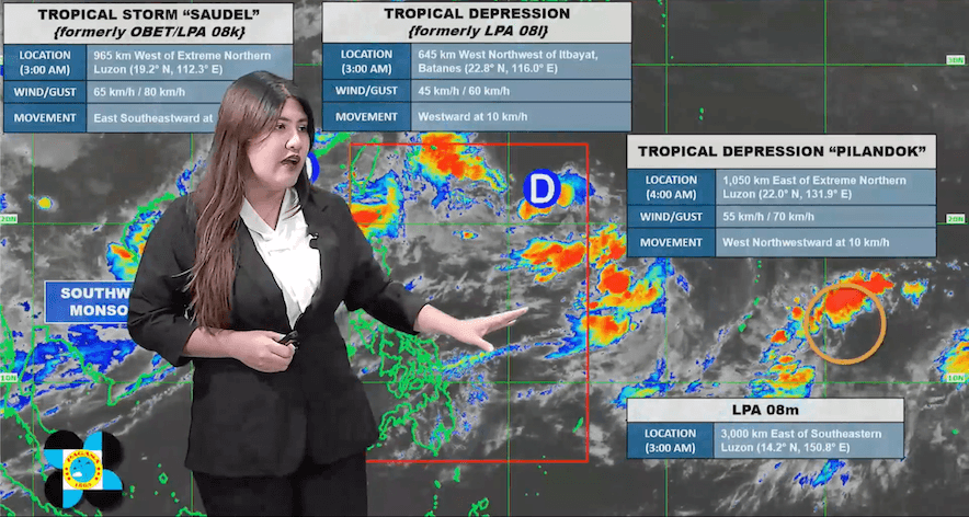
FORECAST. PAGASA Weather Specialist Veronica Torres explains the 5 am forecast for Tropical Depression Pilandok and the southwest monsoon inside the Philippine Area of Responsibility, and the tropical cyclones and low pressure area outside PAR, on September 1, 2026. PAGASA Tropical Depression Pilandok has no direct effect on the country. Meanwhile, no more areas are experiencing heavy to intense rain from the southwest monsoon. Monsoon rain is easing in parts of Luzon, but moderate to heavy rain is still expected in several provinces in the next two days. Strong winds and rough seas are forecasted for coastal and upland areas across Luzon and Visayas, posing risks for vessels. Tropical Depression Pilandok is not expected to affect the Philippines directly, while PAGASA is monitoring other weather systems outside the Philippine Area of Responsibility. This is AI-generated. Read the article for full context. Report any errors. MANILA, Philippines – Monsoon rain started easing on Tuesday, September 1, for parts of Luzon that have been affected by the southwest monsoon or habagat in the past week. In its latest rainfall outlook, the Philippine Atmospheric, Geophysical, and Astronomical Services Administration (PAGASA) said no more areas are experiencing heavy to intense rain (100-200 millimeters) from the southwest monsoon. But Ilocos Norte, Ilocos Sur, La Union, Pangasinan, Batanes, Abra, Benguet, Zambales, and Bataan may still experience moderate to heavy rain (50-100 mm) on Tuesday. Benguet, Zambales, Bataan, and Occidental Mindoro may also see heavy to intense rain again on Thursday, September 3. Below is the rest of the outlook for the next two days: Wednesday, September 2 Moderate to heavy rain (50-100 mm): Ilocos Norte, Ilocos Sur, La Union, Pangasinan, Batanes, Abra, Benguet, Zambales, Bataan, and Occidental Mindoro Thursday, September 3 Heavy to intense rain (100-200 millimeters): Benguet, Zambales, Bataan, and Occidental Mindoro Moderate to heavy rain (50-100 mm): Ilocos Norte, Ilocos Sur, Abra, La Union, Pangasinan, Tarlac, Pampanga, Cavite, and Batangas These areas should watch out for floods and landslides. The southwest monsoon will bring strong to gale-force gusts, especially in coastal and upland areas exposed to winds, over most of Luzon and Visayas, Zamboanga del Norte, Misamis Occidental, Lanao del Norte, Misamis Oriental, Camiguin, Dinagat Islands, Davao Occidental, and Davao Oriental, from Tuesday until Thursday. Moderate to very rough seas will also persist in the following areas: Up to very rough seas (travel is risky for all vessels) Western seaboard of Babuyan Islands; the seaboards of Ilocos Norte — waves up to 5 meters high Western seaboards of Batanes and Pangasinan; the seaboards of Ilocos Sur and northern La Union — waves up to 4.5 meters high Up to rough seas (small vessels should not venture out to sea) Remaining seaboards of Batanes; the northern seaboard of Babuyan Islands — waves up to 4 meters high Seaboard of Zambales; the western seaboard of Bataan — waves up to 3.5 meters high Remaining seaboard of Babuyan Islands; the southern seaboard of Bataan; the western seaboards of Cavite, Batangas, northern Occidental Mindoro, and Calamian Islands; the northern and western seaboards of Lubang Islands and Kalayaan Islands — waves up to 3 meters high Up to moderate seas (small vessels should take precautionary measures or avoid sailing, if possible) Western seaboard of northern Palawan; the eastern seaboard of Davao Oriental; the remaining seaboards of Kalayaan Islands, Pangasinan, and La Union; the northern seaboard of Calamian Islands; the remaining western seaboard of Occidental Mindoro — waves up to 2.5 meters high Seaboards of Cagayan, Isabela, northern Aurora, Romblon, Surigao del Sur, and Davao Occidental; the western seaboard of Burias Island; the southern seaboards of Marinduque and Quezon; the remaining western seaboard of mainland Palawan; the remaining seaboards of Davao Oriental; the northern seaboard of Occidental Mindoro — waves up to 2 meters high Tropical Depression Pilandok, last located 1,050 kilometers east of extreme Northern Luzon, is moving west northwestward at 10 kilometers per hour, with maximum sustained winds of 55 km/h and gustiness of up to 70 km/h. Pilandok has no direct effect on the country and is still less likely to make landfall, although it may develop into a tropical storm in the next 12 hours. It is expected to exit the Philippine Area of Responsibility (PAR) by Wednesday evening or Thursday morning. PAGASA is also monitoring a low pressue area (LPA), a tropical depression, and Tropical Storm Saudel (formerly referred to as Obet), all outside PAR. The tropical depression was last spotted 645 km west northwest of Itbayat, Batanes, moving westward at 10 km/h, with winds of 45 km/h and gustiness of up to 60 km/h. It is not expected to enter PAR. Saudel, now at 965 km west of extreme Northern Luzon, is moving east southeastward at 15 km/h, with winds of 65 km/h and gustiness of up to 80 km/h. It could reenter PAR, after which it will be called Obet again. Meanwhile, the LPA, last located 3,000 km east of southeastern Luzon, is also expected to enter PAR and has a “medium” chance of developing into a tropical depression in the next 24 hours. – Rappler.com How does this make you feel? Loading
Southwest monsoon still affecting Luzon, Western Visayas
Full Article
Original Source
Read the full article at Rappler →KhanList aggregates and links to publicly available news content. We do not host full articles from third-party sources. Always verify important information with original sources.