
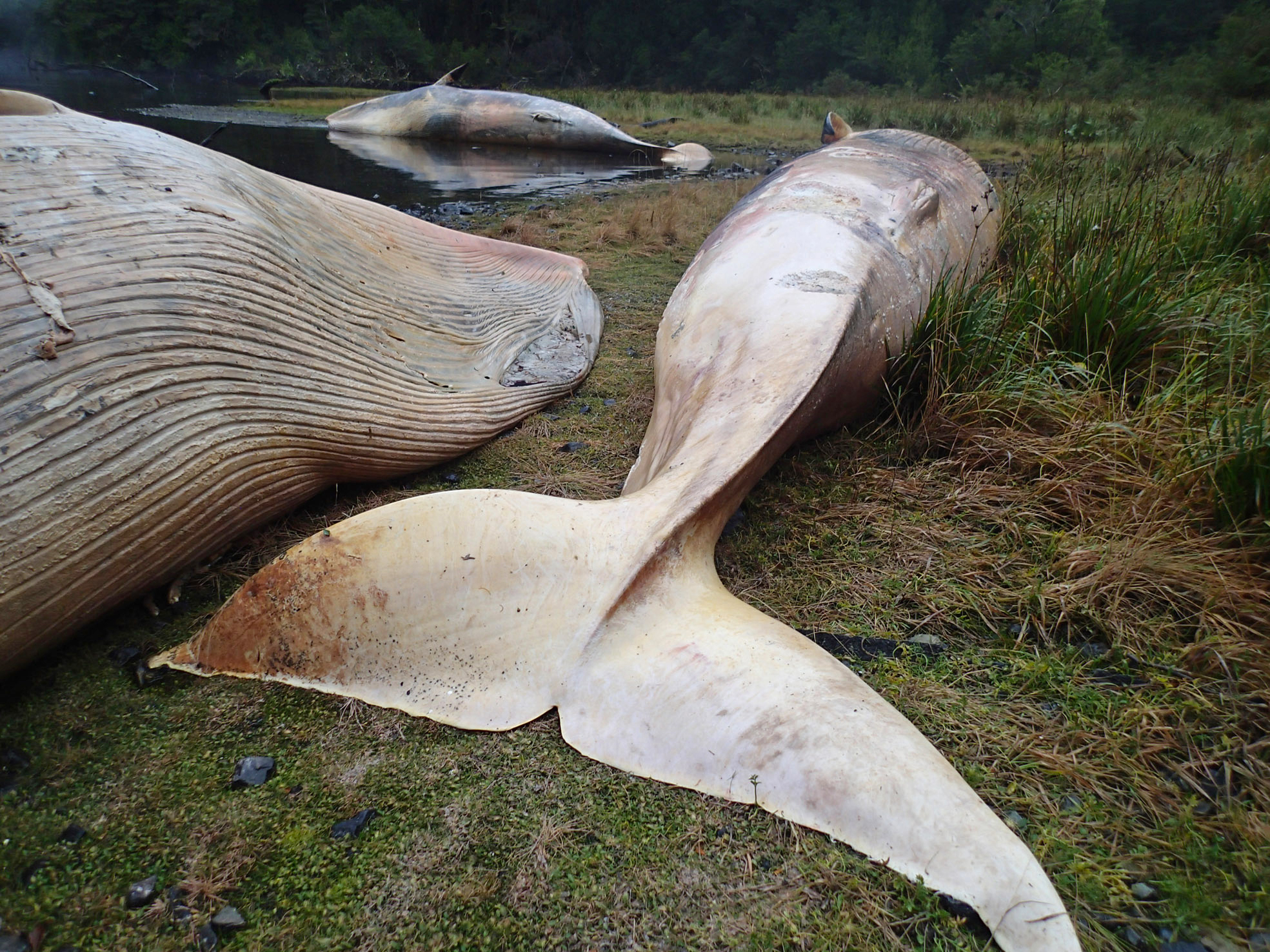
In the early 2000s, attempts to track cetaceans from space yielded only unidentifiable dark blobs; now, very high-resolution satellite imagery allows researchers to pinpoint specific whale species from orbit.This optical satellite technology provides access to remote parts of the world’s oceans, helping scientists establish vital baseline data on whale mortality trends, sea surface temperatures and ocean currents.Researchers emphasize that satellites will supplement, not replace, traditional field-work, as data quality remains vulnerable to environmental limitations, including cloud cover and heavy winds, and to satellite availability.Scientists are building global networks to improve consistency in data collection and are advocating for increased access to satellite data to better understand causes of whale strandings around the world. In 2015, the remote coastal fjords of southern Patagonia turned into a whale graveyard. That June, scientists found 337 dead and decomposing sei whales, a species of baleen whale, on the beaches between the Gulf of Penas and Puerto Natales in Chile. Researchers flew over the area, then took samples from the rotting bodies, trying to find clues as to why this happened. It was later reported to be the largest mass baleen whale mortality event on record. Data collected to determine the cause proved inconclusive, however. Scientists thought the most likely explanation was a toxic red tide provoked by pollution, a strong El Niño event and climate change. What researchers now know for certain, after using very high-resolution satellite images, is that the stranding occurred at least two months before the whales were found. “It’s quite shocking, really,” Penny Clarke, a whale scientist at the British Antarctic Survey (BAS), told Mongabay in a video call. “Think that these whales are about the size of a bus, and there’s 300 … of them, and nobody knew about it for about two months.” The massive stranding in Chile had one bright spot: It offered an important opportunity to test the use of satellite technology to monitor strandings and support data collection on whale mortality. More than 10 years later, Clarke and her BAS colleagues not only use satellite imagery to identify different whale species by observing flippers and flukes in the water, but can spot whale strandings almost anywhere in the world. Using digital eyes in the sky since 2019, they’re part of a global effort pioneering the monitoring of inaccessible coastlines and the tracking of cetaceans. With the number of reported whale strandings rising significantly in some regions during the last two decades, spying on these marine animals from space has become an increasingly important tool in seeking answers about mass die-offs. In the future, scientists hope satellite technology can be used in a systematic manner to spot strandings sooner, intervene more quickly and identify potential causes. A sei whale (Balaenoptera borealis) stranding on the coast of Chile in February 2026. Image by John Collins via iNaturalist (CC BY-NC 4.0). Long-finned pilot whale (Globicephala melas). Image by Vsevolod Rudyi via iNaturalist (CC BY 4.0). Beyond ‘little black blobs’ The tracking of cetaceans using satellite images started in the early 2000s, when the technique was piloted to spot orcas at SeaWorld from space. The cetacea only showed up as black blobs in blue pools. Technological developments have since allowed researchers to translate collected digital information into much higher-resolution images. Today, Earth-orbiting optical satellites capture much more detail, allowing scientists to observe anatomical features that identify species, estimate the stage of decomposition in dead whales, spot body scars and differentiate a calf from its mother by shape and size. The wealth of new data enables researchers to closely monitor both marine and terrestrial wildlife, including elephants, hippos, albatrosses, polar bears and, of course, whales. It’s hoped this large-scale effort will identify variables that can predict stranding events. A longer-term goal of scientists working with satellite imagery, according to Clarke, is to create automated detection models that can efficiently process satellite images to more quickly spot large life forms, allowing researchers to discard irrelevant images and zero in on objects and patterns that may signal strandings. However, Clarke noted that obtaining relevant images is still challenging. Weather conditions, including cloud cover and wind-blown waves, can obstruct the view; stranded animals may have already been removed from an area; or a satellite may be reassigned to a higher priority mission. The BAS now has the largest dataset of remote coastal sites on Earth, Clarke said, but that collection is still too small to train machine learning algorithms. Long-finned pilot whale (Globicephala melas) pod beaching, Australia, July 2023. Image by Bryce van der Heide via iNaturalist (CC BY-NC 4.0). Sperm whales (Physeter macrocephalus). Image by Vincent Kneefel/Ocean Image Bank. A view into remote places The current generation of satellites offers scientists enhanced opportunities for gathering baseline population data from remote regions. Veterinarian and epidemiologist Fernando Mardones, a senior lecturer in One Health and aquaculture at the University of Edinburgh, noted the advantages of using this technology: By reviewing images taken over weeks, months or years, scientists can validate when an animal became stranded. They can also conduct more complete counts of the number of animals that died in a given period of time and calculate more accurate mortality rates for each species, aiding their understanding of stranding patterns and changes in the frequency of such events. “I am certainly in favor of the use of high-resolution satellite imagery,” Mardones told Mongabay in a video call. “The aim today is to try to understand why animals become stranded, and [satellite] research helps, in part, to answer those kinds of questions.” Researchers can also use satellites with specialized sensors to collect data on environmental conditions that may be affecting whales, such as sea surface temperature, chlorophyll concentration, surface waves and ocean currents. While satellites can facilitate greater understanding of circumstances that may contribute to strandings, it’s not a substitute for on-the-ground observation and data collection, according to Clarke. “Satellites are not going to replace any of the tools that exist,” Clarke said, adding that the images are most useful for alerting researchers to strandings in remote locales that are hard to access in person. Scientists must still check satellite images against field observations and collected samples, as Clarke did in 2024 in the U.K.’s Orkney Islands and Humber Estuary. After using satellite imagery to track stranding events of pilot whales (Globicephala melas) and sperm whales (Physeter macrocephalus), she visited the sites in person to validate the data. “You can’t work out the cause of the stranding from the satellite imagery, you’d have to do some sort of necropsy,” Clarke said. Satellite images of stranded sei whales in Chile in 2015. Satellite image ©2026 Vantor. Satellite images of stranded sei whales in Chile in 2015. Satellite image ©2026 Vantor. Satellite images of stranded sei whales in Chile in 2015. Satellite image ©2026 Vantor. Building global networks In the future, scientists hope satellite technology advancements, faster processing of images and better data integration will improve understanding of why whales get stranded and whether the number of strandings is increasing. Both remain subjects of debate. New Zealand is considered a hotspot, with more than 5,000 stranded whales recorded, including 55 so far this year. A study published in 2020 analyzed whale strandings occurring over 50 years in Patagonian Chile, the same region where the 2015 mass stranding occurred, and found that the number of reported strandings had grown considerably in the last two decades. However, increased reporting may have played a role in that perceived increase, Mardones, coauthor of the 2020 study said. “There is a whole bias from the fact that people are now more aware of events occurring along the coast, and access to the coast is also much greater today than it was 50 years ago,” he said. Facing a raft of uncertainties, scientists have now joined forces, forming collaborations including the Global Stranding Network, a group of international biologists, veterinarians, conservationists and others aiming for quick, high-quality responses to stranding events worldwide. Network members want to break down research barriers, including high costs and access restrictions, in order to regularly use satellite imagery to aid local action and gain greater understanding of why strandings happen. These networks encourage researchers and other professionals to collaborate and standardize methodology so data collection is comparable and can be used across the globe, said Mardones. This team approach allows scientists to rigorously analyze relevant but wide-ranging variables, such as climate change, ocean temperature, migration routes, behaviors, surrounding noises, pollution, collisions with ships and many other factors that could be involved in strandings. Increased access to satellite data plays a key role. “The effort today is more of a scientific one; an ethical endeavor in light of having a better understanding of what is happening,” Mardones said. “I believe that our commitment as human beings to respect and protect nature is very important.” Banner image: Dead sei whales (Balaenoptera borealis) in a remote fjord of Central Patagonia in 2015, the largest baleen whale mass mortality event ever recorded. The initial discovery was made by biologist Vreni Häussermann, who works with Patagonia Projects, the core platform for whale studies in Chile’s Golfo Tres Montes. Image courtesy of Vreni Häussermann. Gray whales are suffering catastrophic population decline in the Pacific Ocean Citations: Alvarado-Rybak, M., Toro, F., Escobar-Dodero, J., Kinsley, A. C., Sepúlveda, M. A., Capella, J., … Mardones, F. O. (2020). 50 years of cetacean strandings reveal a concerning rise in Chilean Patagonia. Scientific Reports, 10(1). doi:10.1038/s41598-020-66484-x Clarke, P. J., Cubaynes, H. C., Jackson, J. A., Taylor, N. L., Johnston, D. W., De Vos, A., … Jones, G. (2025). Talking about the weather: The feasibility of using very high‐resolution optical satellite imagery to monitor live and stranded cetaceans around the UK and UK overseas territories. Marine Mammal Science, 42(1). doi:10.1111/mms.70074 Clarke, P. J., Cubaynes, H. C., Stockin, K. A., Olavarría, C., De Vos, A., Fretwell, P. T., & Jackson, J. A. (2021). Cetacean strandings from space: Challenges and opportunities of very high resolution satellites for the remote monitoring of cetacean mass strandings. Frontiers in Marine Science, 8. doi:10.3389/fmars.2021.650735 Fretwell, P. T., Jackson, J. A., Ulloa Encina, M. J., Häussermann, V., Perez Alvarez, M. J., Olavarría, C., & Gutstein, C. S. (2019). Using remote sensing to detect whale strandings in remote areas: The case of sei whales mass mortality in Chilean Patagonia. PLOS ONE, 14(10), e0222498. doi:10.1371/journal.pone.0222498 Maglione, P. (2016). Very high resolution optical satellites: An overview of the most commonly used. American Journal of Applied Sciences, 13(1), 91-99. doi:10.3844/ajassp.2016.91.99 Feedback: Use this form to send a message to the editor of this post. If you want to post a public comment, you can do that at the bottom of the page. Credits Topics
Scientists use satellites to track whale strandings in remote places from space
Full Article
Original Source
Read the full article at News →KhanList aggregates and links to publicly available news content. We do not host full articles from third-party sources. Always verify important information with original sources.