
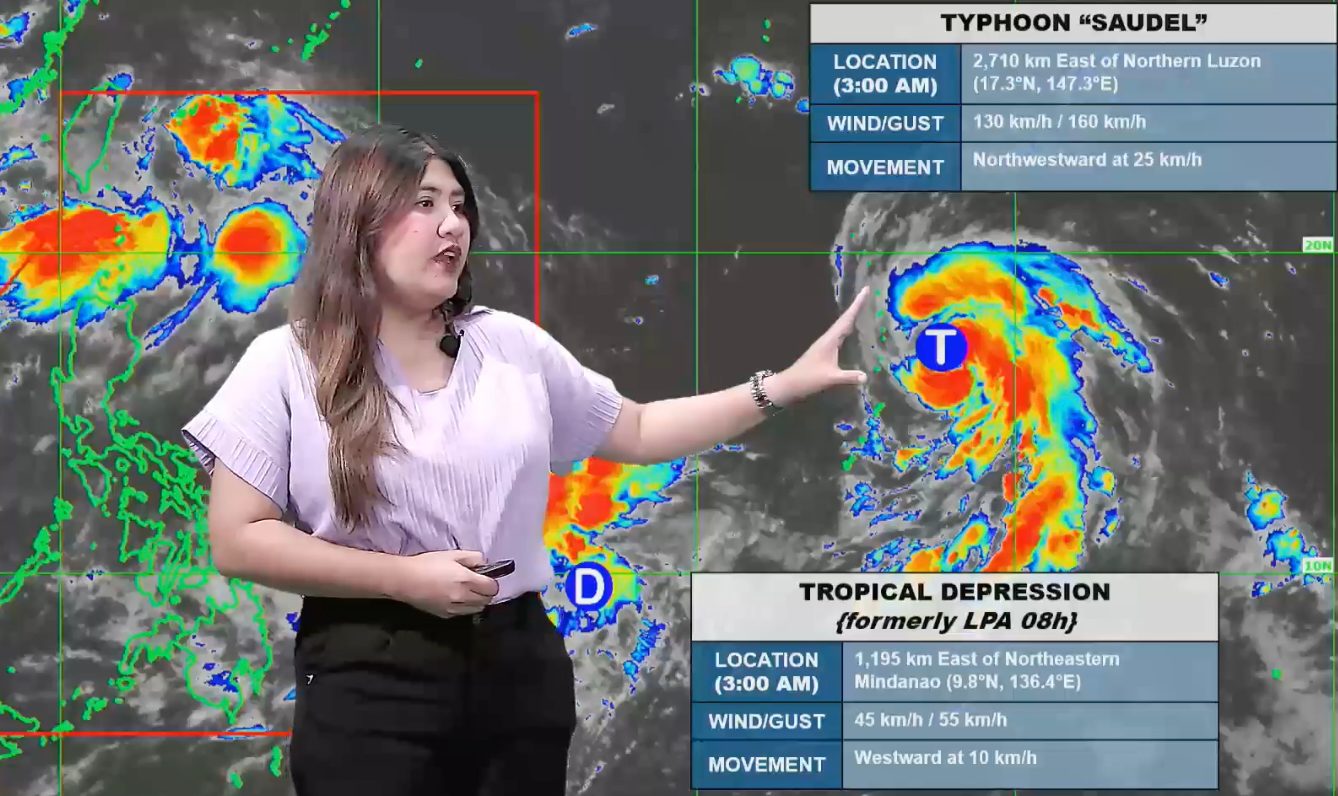
FORECAST. PAGASA Weather Specialist Veronica Torres explains the bureau's 4 am forecast for Typhoon Saudel and the tropical depression, both outside the Philippine Area of Responsibility, on August 22, 2026. PAGASA PAGASA is not ruling out the possibility of the tropical depression entering the Philippine Area of Responsibility ahead of Typhoon Saudel Saudel intensified into a typhoon outside the Philippine Area of Responsibility on Friday, August 21. A low pressure area also outside PAR developed into a tropical depression on Saturday, August 22. This is AI-generated. Read the article for full context. Report any errors. MANILA, Philippines – Saudel strengthened from a severe tropical storm into a typhoon at 8 pm on Friday, August 21, while the low pressure area (LPA) also being monitored developed into a tropical depression at 2 am on Saturday, August 22. Both are located outside the Philippine Area of Responsibility (PAR). The Philippine Atmospheric, Geophysical, and Astronomical Services Administration (PAGASA) said Saudel was located 2,710 kilometers east of Northern Luzon as of 3 am on Saturday, moving northwest at 25 kilometers per hour. Its maximum sustained winds are now at 130 km/h, with gustiness of up to 160 km/h. The typhoon is still projected to enter PAR by Monday, August 24. It might stay far from Philippine landmass, but it is likely to enhance the southwest monsoon or habagat. The expected enhancement of the southwest monsoon would mean significant rainfall, especially in Luzon, during the last week of August. For now, the southwest monsoon is bringing scattered rain and thunderstorms to the Ilocos Region, Cordillera Administrative Region, Batanes, Cagayan, Zambales, Bataan, Tarlac, and Pampanga, as well as isolated rain showers or thunderstorms to the rest of Cagayan Valley, the rest of Central Luzon, Metro Manila, and Calabarzon on Saturday. Flash floods and landslides remain possible during periods of moderate to heavy rain or severe thunderstorms. Meanwhile, the tropical depression was located 1,195 kilometers east of northeastern Mindanao as of 3 am on Saturday — right outside PAR. It is moving west at just 10 km/h, with maximum sustained winds of 45 km/h and gustiness of up to 55 km/h. PAGASA Weather Specialist Veronica Torres said the weather bureau is not ruling out the possibility of the tropical depression entering PAR ahead of Saudel, since it is “momentarily” heading west. But afterwards, she explained, it could move northeast or away from the Philippines. PAGASA also continues to monitor the LPA or remnant low that used to be Tropical Depression Neneng. It was last spotted 735 kilometers north northeast of Itbayat, Batanes, at 3 am on Saturday. The remnant low has a medium chance of redeveloping into a tropical cyclone within 24 hours, but it continues to move away from PAR. PAGASA previously estimated that up to four tropical cyclones may develop within or enter PAR in August. So far, there have been three during the month: Tropical Depression Luis, Tropical Storm Maymay (Kujira), and Neneng. The next two local tropical cyclone names are Obet and Pilandok. – Rappler.com How does this make you feel? Loading
Saudel now a typhoon, LPA becomes tropical depression outside PAR
Full Article
Original Source
Read the full article at Rappler →KhanList aggregates and links to publicly available news content. We do not host full articles from third-party sources. Always verify important information with original sources.