
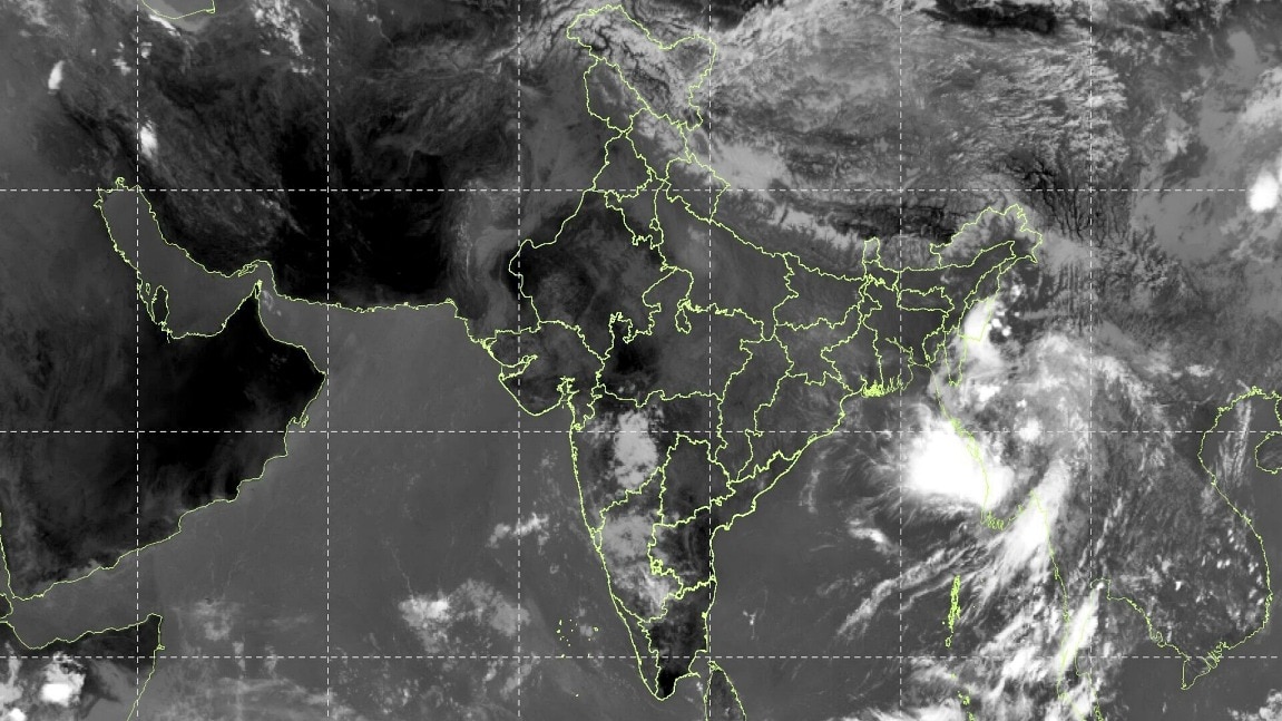
The southwest monsoon is steadily pulling away from northwest India, and satellite images are beginning to capture the change from a rain-filled season to a drier phase.The shift is most visible across parts of northwest and central India, where the thick cloud cover associated with recent spells of rain is giving way to clearer stretches.The change comes as the monsoon withdrawal advances south and east, leaving behind a more typical post-monsoon weather pattern. A cloudless India is seen from space as monsoon withdrawal continues. (Photo: Windy) MONSOON WITHDRAWAL MARCHES AHEADThe India Meteorological Department (IMD) said the withdrawal line currently passes through Gurdaspur, Chandigarh, Muzaffarnagar, Aligarh, Dholpur, Udaipur, Deesa and Naliya, before extending towards the Arabian Sea. The monsoon had begun retreating from west Rajasthan around September 19 and withdrew from Delhi on September 23, bringing the capital's monsoon season to an end slightly ahead of its usual September 25 date. Children play on Kartavya Path amid rain. (Photo: PTI) The withdrawal is, however, not simply about the rain stopping. The IMD considers a sustained break in rainfall, a change in lower-level winds and a marked fall in atmospheric moisture while determining the retreat of the monsoon. A satellite image shows most of India without any cloud cover. (Photo: IMD) CLEAR SKIES, BUT MONSOON NOT OVER EVERYWHEREThe latest satellite view shows how dry the subcontinent is.Much of northwest India is seeing far less of the widespread cloud cover that accompanied recent rain spells, while cloud activity remains over parts of eastern and southern India.That means the change will not happen uniformly across the country. A man walks with an umbrealla amid rain. (Photo: Getty) The monsoon is still present over several regions, even as its influence weakens across the northwest.The IMD's latest update also shows no weather warning for Haryana, Chandigarh and Delhi through October 4, pointing to a relatively calm spell over the region.WHAT HAPPENS NEXT?The withdrawal of the southwest monsoon from the entire country is a longer process. A satellite image shows clear skies over the Indian subcontinent. (Photo: Windy) The IMD said that further withdrawal is assessed using the continuity of the retreat, falling moisture and the persistence of dry weather.Meanwhile, the complete withdrawal happens only after October 1 when the broader circulation pattern shifts away from the southwesterly wind regime.So, while the skies over northwest India are increasingly looking like the monsoon is packing up, the season has not yet disappeared from the rest of the country.For now, all that the satellite picture tells is that the seasonal retreat is well underway.- Ends
No more rain? Satellite captures most of India without monsoon clouds
Full Article
Original Source
Read the full article at Indiatoday →KhanList aggregates and links to publicly available news content. We do not host full articles from third-party sources. Always verify important information with original sources.