
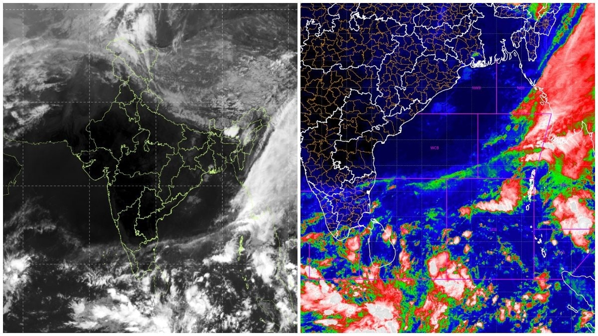
INSAT-3DS imagery has captured extensive cloud formations over the Bay of Bengal. The developing system could bring heavy rain, although cyclone formation remains unconfirmed.The India Meteorological Department (IMD) is monitoring a developing weather system. (Photo: IMD)New Delhi,Nov 11, 2026 12:28 ISTIs another cyclone brewing over the Bay of Bengal? A fresh weather system is showing signs of development over the region, with India's east coast potentially facing another spell of heavy rainfall in the coming days.Satellite imagery from India's INSAT-3DS satellite on November 11 has captured extensive cloud formations over the Bay of Bengal and adjoining regions. The thermal infrared image reveals widespread convective cloud activity over the southern Bay, while another large cloud band stretches along the eastern side of the Indian subcontinent.The satellite image offers a glimpse of the evolving atmospheric conditions, but it does not confirm the formation of a cyclone. The India Meteorological Department (IMD) is monitoring a developing weather system that could organise into a low-pressure area later this week. Photo: Windy According to the latest IMD forecast, a low-pressure area is likely to form over the southeast Bay of Bengal around November 13, 2026. The system is expected to move northwestwards and become a well-marked low-pressure area over the subsequent 24 hours. While the possibility of further intensification cannot be ruled out, there is currently no confirmation that the system will develop into a cyclonic storm. Its eventual track, intensity and impact will depend on how atmospheric conditions evolve over the coming days.TAMIL NADU, ANDHRA PRADESH ON WEATHER WATCHThe developing system comes as parts of southern India remain under the influence of active weather conditions. The IMD has forecast isolated heavy rainfall over Tamil Nadu, Puducherry and Karaikal on November 10 and 11. Another spell of isolated heavy rainfall is likely over these regions on November 15 and 16.Kerala and Mahe could also receive isolated heavy rainfall on November 16. Photo: IMD The system's northwestward movement could bring changing weather conditions over parts of the eastern coast, including Tamil Nadu and Andhra Pradesh, although the extent of rainfall will become clearer as the system develops.IS ANOTHER CYCLONE IMMINENT?The Bay of Bengal has repeatedly witnessed the development of powerful weather systems, particularly during the post-monsoon cyclone season between October and December.However, a low-pressure area does not automatically become a cyclone. It needs favourable atmospheric conditions, including warm sea surface temperatures, sufficient moisture, low vertical wind shear and sustained atmospheric circulation.For now, the developing system remains under observation. The next 24–48 hours will be crucial in determining whether the low-pressure area strengthens and whether India's eastern coastline needs to prepare for a potential cyclonic threat.- Ends
New cyclone brewing in Bay of Bengal? Isro satellite reveals what's happening
Full Article
Original Source
Read the full article at Indiatoday →KhanList aggregates and links to publicly available news content. We do not host full articles from third-party sources. Always verify important information with original sources.