
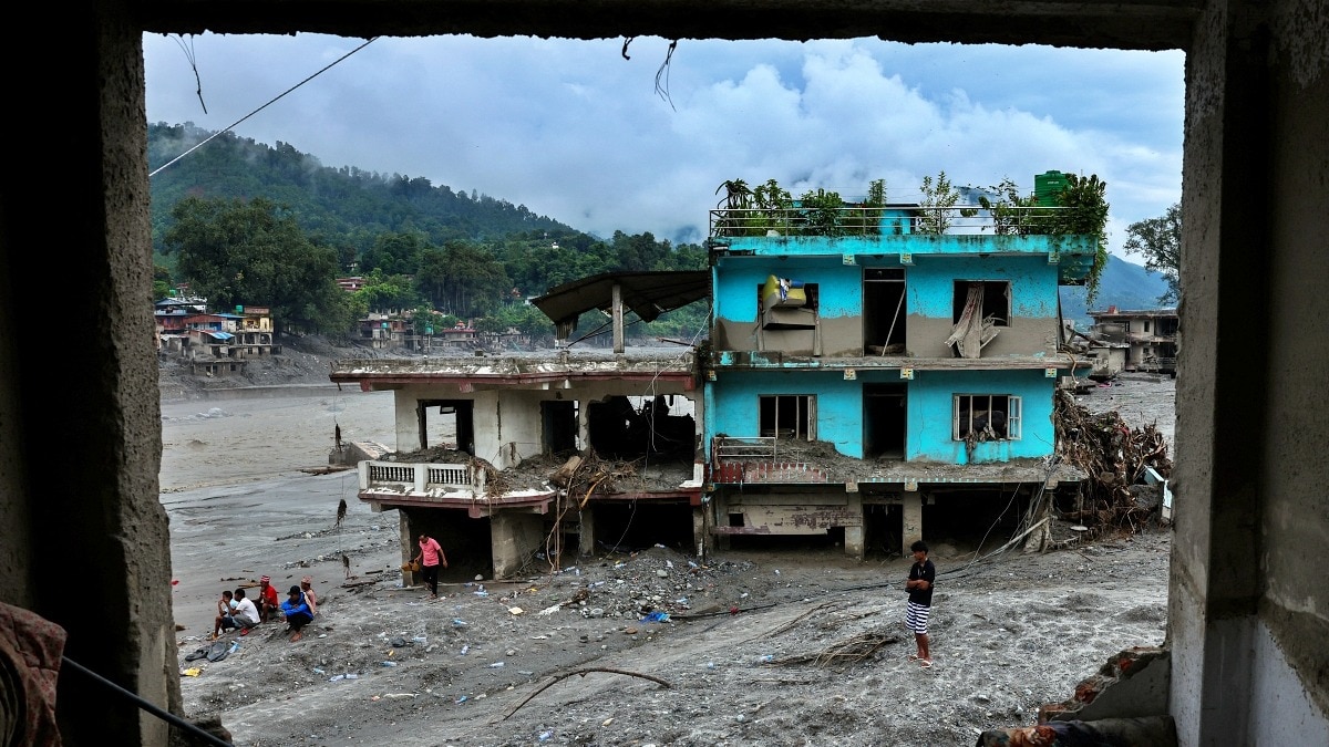
A deadly avalanche-driven flood in Nepal has raised fresh concern across the Indian Himalayas. Scientists say India cannot predict an identical event, but expanding lakes and unstable slopes need closer monitoring.People next to damaged buildings near the Trishuli River, following the deadly flash floods and a mudslide, in Devighat, Nuwakot district, Nepal. (Photo: Reuters)It began high above the villages of Nepal, in a part of the Himalayas where few people could have seen the disaster coming.On August 26, a massive wall of ice, rock and debris broke loose near the Nepal-Tibet border and came crashing down the mountainside. Within moments, the remote Himalayan landscape was transformed into a deadly chain reaction.The avalanche slammed into the Bhote Koshi river system, choking and redirecting the flow before unleashing a violent surge downstream. The flood raced through mountain valleys with terrifying speed.Bridges disappeared. Roads were cut off. Buildings were swallowed by mud, boulders and debris. In Betrawati, satellite imagery later revealed parts of the commercial heart of the town buried beneath the wreckage, while power infrastructure and critical links to the outside world were damaged. But perhaps the most unsettling discovery came after the flood.Satellite images of the disaster zone revealed that the avalanche had left behind a newly formed lake at the source of the catastrophe. High in the mountains, water was beginning to accumulate behind the debris, raising fears of another potential outburst in an already devastated river system. For India, the images from Nepal carry an uncomfortable message. The Himalayas do not recognise political borders.The glaciers, unstable slopes and rapidly changing high-altitude lakes that triggered concern in Nepal continue across the Indian Himalayas. Damaged buildings next to Trishuli River following the deadly flash floods and mudslides in Nuwakot district, Nepal. (Photo: Reuters) From Himachal Pradesh to Sikkim and Arunachal Pradesh, glaciers are retreating, new lakes are forming and existing lakes are expanding.Could the next Himalayan disaster unfold on the Indian side?INDIA ON ALERT: HIMALAYAS BECOMING UNSTABLEScientists caution that it would be wrong to predict that India will experience an exact repeat of Nepal. Every mountain, glacier and river valley has its own geology and triggers.But research from the Indian Himalayas is revealing warning signs that are becoming increasingly difficult to ignore.The question is no longer simply whether a glacial lake can burst. For India, the images from Nepal carry an uncomfortable message. The Himalayas do not recognise political borders. (Photo: Getty) The greater fear is what happens when an already fragile Himalayan landscape begins to fail in sequence, when a glacier collapses, an avalanche crashes into a lake, a landslide blocks a river, extreme rain destabilises a slope, and millions of tonnes of water and debris suddenly find a path downhill.And in the narrow, heavily populated valleys of the Himalayas, there may be very little time to get out of the way.The tragedy has now sent an uncomfortable question echoing across the Indian Himalayas: Could a Nepal-like flash flood catastrophe strike India?COULD A NEPAL-LIKE FLASH FLOOD CATASTROPHE STRIKE INDIA?The answer from scientists is not a simple yes.India cannot scientifically predict that Nepal's tragedy will repeat itself across the border. The precise triggers, geology, glaciers and river valleys are different. But the warning signs are increasingly visible.Across the Himalayas, glaciers are retreating, lakes are growing, slopes are becoming unstable, and infrastructure is expanding deeper into narrow mountain valleys. The ingredients for disaster exist.The uncertainty lies not in whether the mountains are changing, but in knowing exactly when and where the next cascade could begin.Professor Dericks Praise Shukla, Professor of Remote Sensing and GIS at IIT Mandi, says the first task is to understand where the danger is concentrated.His team's assessment of Himachal Pradesh identified roughly 2,000 lakes and compared their extent between 2015 and 2025. The research then classified them according to whether they were directly connected to glaciers, disconnected from them or located close enough to potentially receive glacier-fed water.Lakes continuously fed by melting glaciers are particularly important because they continue to receive fresh water input.But a growing lake does not automatically mean an impending disaster.That is one of the most important distinctions emerging from the research.The IIT Mandi assessment examined not just lake size but also the material forming the natural barrier holding the water back. A lake contained by solid bedrock presents a very different hazard from one held behind loose debris. Moraine dams may be stronger than unconsolidated debris, but they remain weaker than bedrock.The researchers also examined the dimensions of these natural barriers, including their length, width and height. The physical characteristics of the dam can influence how vulnerable it may be to failure.Over the past decade, the number and total area of glacier lakes in Himachal Pradesh have increased, according to the assessment. The researchers then used multiple parameters and expert inputs to rate the lakes, with around nine emerging as highly critical and potentially dangerous.Yet hazard is not the same thing as risk. A man who survived is carried by members of a search and rescue team after being rescued from inside a tunnel at the Trishuli-3A Hydropower Project. (Photo: Reuters) COULD THESE GLACIAL LAKES BREACH?A lake may have the potential to breach and release a large volume of water, but if there are no villages, roads, hydropower projects or other assets downstream, the consequences may be limited.Conversely, a smaller event in a densely populated valley packed with infrastructure can turn into a major disaster.“Disaster risk exists only when exposed elements are present in the path of a hazard,” the analysis shared by Suhora Technologies noted. Those exposed elements include settlements, roads, bridges, tunnels, dams, schools and healthcare facilities.A growing lake, therefore, becomes a much more serious concern when vulnerable communities and infrastructure lie downstream. The Himalayas are filled with glacial lakes. This distinction is crucial when looking at lakes such as Samudra Tapu in Himachal Pradesh.The lake is connected to the Tapu Glacier, is large and has been expanding. It could potentially generate a significant flood if it breached. However, the assessment suggests that its overall downstream risk is relatively lower because settlements and other assets are far away and the river slope downstream is comparatively gentle.That does not mean India can relax.INDIA NEEDS TO ENHANCE MONITORINGThe Himalayas are particularly dangerous because disasters rarely occur in isolation.A glacier or ice-rock avalanche can fall into a lake. A landslide can block a river and suddenly create a temporary lake.Extreme rainfall can destabilise slopes. An earthquake can weaken a natural dam. A rapidly expanding glacial lake can breach.One event can trigger another.The Nepal tragedy itself illustrates this cascading danger. According to the analysis shared by Suhora Technologies, the disaster was triggered by an ice-rock avalanche rather than a conventional Glacial Lake Outburst Flood, or GLOF. But the debris altered the river system and created a new lake at the source of the disaster.Satellite imagery captured on August 27 identified the newly formed water body in the Lhende Khola region, covering approximately 20.25 hectares. A lake formed at the source of an avalanche and debris-flow event could continue accumulating water, making its stability a critical issue for monitoring.Union Home Secretary Govind Mohan reviewed the preparedness of Himalayan states and Union Territories against the risks of Glacial Lake Outburst Floods (GLOFs) and snow avalanches on Thursday.Vulnerabilities and preparedness measures specific to each state and UTs were discussed in detail, with emphasis on ensuring that mitigation measures are translated into concrete actions at the district and local levels. Satellite images show before and after damage in Nepal. (Photo: Vantor) INDIA NOT UNTOUCHED BY GLACIAL DISASTERSIndia has already witnessed how devastating Himalayan cascades can be.The 2021 Chamoli disaster, the South Lhonak Lake outburst in Sikkim in 2023, the Dharali deluge and major landslide disasters have repeatedly demonstrated that mountain hazards can rapidly transform into downstream catastrophes.Scientists may be able to identify vulnerable areas, but predicting the exact moment when a slope collapses, or a natural dam fails remains extraordinarily difficult.For Himachal Pradesh, Professor Shukla says the next major scientific step is hydrodynamic modelling.Identifying a potentially dangerous lake is only the beginning. Scientists then need to know how much water it contains and what would happen if it breached. Hydrodynamic models can estimate flood depth, lateral spread and how the flood wave would travel through a river valley.But accurate modelling requires reliable information about lake volume.Remote sensing can precisely track changes in lake area, but estimating water volume from satellite-derived area alone can involve significant uncertainty. Empirical formulas may overestimate volumes substantially, making it difficult to accurately model the consequences of a potential breach.Some Himalayan lakes have already been studied in greater detail. Research on Gepang Gath in Himachal Pradesh has suggested that a major outburst could affect downstream areas, including settlements around Sissu, with impacts extending further along the valley.Still, Professor Shukla cautions against making dramatic predictions.It would not be scientifically correct to declare that a Nepal-like disaster will happen in Himachal Pradesh. The physical mechanisms that trigger Himalayan disasters vary from place to place.What scientists can say is that hazardous lakes exist, glaciers and landscapes are changing, and an event at some locations could damage communities and infrastructure downstream.The warning signs are not limited to Himachal Pradesh.WARNING SIGNALS ACROSS HIMALAYASAn assessment by Suhora Technologies in Arunachal Pradesh's Tawang district found that four of five potentially dangerous glacial lakes in the Mago Chu Basin had expanded between 2016 and 2026.The lakes had previously been identified in high-risk categories, and satellite observations showed changing patterns of water accumulation.Sanhapo Lake stood out in the analysis. Satellite observations showed its measured area increasing from 55.87 hectares in 2016 to 87.02 hectares in 2026 and 88.81 hectares in the latest June 2026 observation.Suhora's analysis said its size, continued expansion and existing high-risk classification made it a priority for detailed hazard modelling and continuous monitoring. A satellite view of an area with a school complex, after the flash floods and mudslides, in Bidur. (Photo: Reuters) For Professor Shukla, the way forward is not to attempt the impossible task of predicting the exact date of the next Himalayan catastrophe.It is to build a better system for seeing danger before it arrives.That means satellites scanning vast mountain regions for changing lakes and unstable landscapes, followed by targeted deployment of ground sensors at the most critical locations. His research points to a two-tier approach: broad synoptic monitoring from space to identify hotspots, followed by focused on-ground monitoring and warning systems.The Himalayas may never offer perfect predictions.But Nepal's tragedy has delivered a strong shakeup: disasters in the mountains can begin with a collapse that nobody sees, high above a valley where people below may have no idea what is coming.India may not face an identical disaster. It does not need to.The Indian Himalayas have their own glaciers, lakes, valleys and vulnerabilities. And increasingly, they are sending signals that the time to study the next catastrophe is before the mountain begins to move.- EndsPublished By: Sibu Kumar TripathiPublished On: Sep 5, 2026 11:00 IST
Nepal's flood disaster raises a chilling question: Could India be next?
Full Article
Original Source
Read the full article at Indiatoday →KhanList aggregates and links to publicly available news content. We do not host full articles from third-party sources. Always verify important information with original sources.