
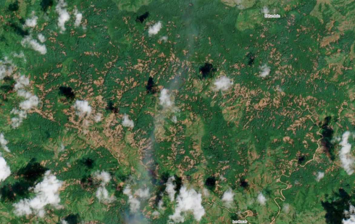
ESA Sentinel-2 L2A image captured on 18 October 2026 showing landslides triggered by the 9 October earthquake in Pananma. ESA Sentinel satellite images show that hundreds of landslides were triggered by the earthquake earlier this month. On 9 October 2026, a Mw 7.7 earthquake struck the Azuero Peninsula in Panama (epicentre at [7.587, -80.769]. This shallow (depth = 12.6 km) had the potential to trigger landslides in an area that has significant relief. Fortunately, the low population density meant that the loss of life was minimal. The ESA Sentinel 2 satellite captured a good image of the impacted area on 18 October 2026 – this can be accessed via the Sentinel Hub. This reveals a very dense area of landslides in the vicinity of [7.47737, -80.86495]. This is the image:- ESA Sentinel-2 L2A image captured on 18 October 2026 showing landslides triggered by the 9 October earthquake in Panama. Imagery from 9 September 2026 shows that this is an area that had limited numbers of landslides before the earthquake. These appear to be primarily shallow landslides in area of dense forestry. Note that they have not translated into channelised debris flows – this reflects the seismic rather than rainfall triggering. Interestingly, this cluster of landslides, which is close to the epicentre, corresponds to the area of densest landslides forecast by the USGS PAGER ground failure model for this earthquake, which shows how good this model has become. The rainy season in Panama runs from May to December, with peak rains in October and November. However, this year Panama has been affected by a severe drought, with very little rainfall, possibly associated with El Nino. Thus, there has been little opportunity for these areas of landslides to expand to date, or for the debris to mobilise. The next period of heavy rainfall is likely to see significant additional landslide occurrence. Some initial analysis of these landslides has been completed by the Institute of Geosciences at the University of Panama. News reports suggest that they have mapped 2,351 landslides to date. I shall look forward to see a publication analysing these landslides. Text © 2026. The authors. CC BY-NC-ND 3.0Except where otherwise noted, images are subject to copyright. Any reuse without express permission from the copyright owner is prohibited.
Landslides triggered by the 9 October 2026 Mw =7.7 earthquake in Panama
Full Article
Original Source
Read the full article at Eos →KhanList aggregates and links to publicly available news content. We do not host full articles from third-party sources. Always verify important information with original sources.