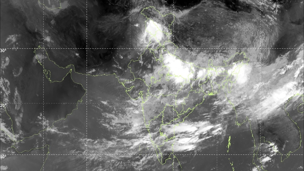
Isro's INSAT-3DR satellite images show clouds covering nearly two-thirds of India on July 19 as the monsoon turns active. Here is how satellites measure cloud cover and what cloud top temperatures reveal about storms.Monsoon clouds drape nearly two-thirds of India in this satellite image captured on the morning of July 19. (Photo: IMD)If you could float above India on the morning of July 19, you would struggle to find the ground.Satellite images show a vast shield of monsoon clouds draped over the country, stretching from Jammu and Kashmir down the Gangetic plains and across to the Northeast.HOW MUCH OF INDIA IS COVERED BY CLOUDS?An analysis of the visible satellite image and the INSAT-3DR infrared image, both captured on July 19, suggests that roughly 60 to 70 per cent of India's landmass is under cloud cover.That is nearly two-thirds of the country. The INSAT-3DR infrared image for July 19 marks the coldest, tallest storm clouds with red and purple contours over Jammu and Kashmir, the Gangetic plains and the Northeast. (Photo: IMD) The thickest clouds sit over the northern plains, from Punjab through Uttar Pradesh and Bihar to West Bengal, and over the Northeast. Long bands of cloud also streak across the southern peninsula, fed by moist winds from the Arabian Sea.Western Rajasthan and parts of Tamil Nadu are comparatively clear. The figure is an estimate drawn from the imagery, and it shifts through the day as clouds build and decay.HOW DO SATELLITES SEE CLOUDS FROM SPACE? INSAT-3DR, a weather satellite built by the Indian Space Research Organisation (Isro), watches the subcontinent from a geostationary orbit about 36,000 kilometres above the equator.This means it hovers over the same spot and photographs the country every half hour, according to the India Meteorological Department (IMD), which uses its data for forecasting.The satellite has two main sets of eyes. The visible channel works like an ordinary camera, using reflected sunlight. The brighter and whiter a cloud appears, the thicker it is.The thermal infrared channel, at a wavelength of 10.8 micrometres, senses heat instead of light, so it works day and night. It measures how warm or cold the top of each cloud is.WHAT IS CLOUD TOP BRIGHTNESS TEMPERATURE?Cloud Top Brightness Temperature, or CTBT, is simply the temperature of a cloud's upper surface as seen by the satellite. It is not the temperature you feel on the ground.Air in the lower atmosphere cools by about 6.5 degrees Celsius for every kilometre of height. Bands of moisture-laden monsoon clouds stream across the Arabian Sea towards the west coast, feeding rainfall over peninsular India. Deep convective clouds, shown in red and orange, cluster over eastern and northeastern India while the Bay of Bengal stays relatively quiet. (Photo: IMD) So, the colder a cloud top, the taller the cloud. Tops colder than minus 40 degrees Celsius mark deep thunderclouds, and anything below minus 70 signals violent storms punching towards the top of the troposphere, as described in the IMD's satellite meteorology procedures.The July 19 CTBT image shows tops colder than minus 80 degrees Celsius over Jammu and Kashmir, with pockets below minus 50 over Uttar Pradesh, Bihar, Jharkhand, the Northeast, and in bands over Karnataka, Telangana and Andhra Pradesh.DOES CLOUD COVER MEAN IT IS RAINING EVERYWHERE?No. The cloudy two-thirds includes a harmless high cirrus and grey monsoon overcast that yields little more than drizzle.The heavy rain falls only under the deepest storm cores, which occupy well under a tenth of the country at any instant. The coldest cloud tops, below minus 80 degrees Celsius, mark towering monsoon thunderstorms over Jammu and Kashmir, the Gangetic plains and the Northeast. (Photo: Windy) Those storms are self-powering. Every kilogram of water vapour that condenses releases about 2.5 million joules of heat, driving updrafts that push clouds 15 kilometres high.With the monsoon trough active across northern India, that engine is running at full throttle.- EndsPublished By: Radifah KabirPublished On: Jul 19, 2026 10:19 IST
Isro satellite images show clouds over nearly two-thirds of India: What to expect
Full Article
📰 Original Source
Read full article at Indiatoday →KhanList aggregates and links to publicly available news content. We do not host full articles from third-party sources. Always verify important information with original sources.