
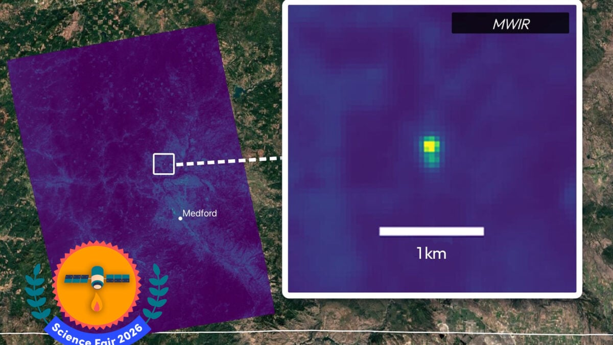
Earth Fire Alliance is a winner of the 2026 Gizmodo Science Fair for developing a satellite constellation dedicated to the early detection of potentially dangerous wildfires. For years, firefighters and scientists have watched wildfires from space using satellites built to do many things—but not specifically to find fires. By the time those satellites detect a fire and send the data back to Earth, a tiny blaze can already have become a fast-moving wildfire. The FireSat constellation is designed to change that: a network of satellites built specifically to spot fires early, providing near real-time data that could give firefighters a crucial window to act before a small flame turns into a major disaster. The question Can a satellite constellation be used to detect small, cool ignitions from space before they escalate and, in turn, generate a global dataset that can help scientists better understand the behavior of fire? The results On July 7, the Earth Fire Alliance (EFA) launched the first three operational satellites for the FireSat constellation. EFA formed in 2024, with FireSat as its flagship project that aims to confront the escalating dangers of wildfires worldwide. As the first satellite constellation designed specifically for wildfire detection, FireSat uses advanced sensors to detect reflected or emitted thermal radiation from Earth’s surface. “As the satellite orbits over a section of the planet, it’s got a scanning mirror that basically takes either that reflected sunlight or the thermal energy emitted by a fire and directs it into the optics of the camera,” EFA’s lead scientist Michael Falkowski told Gizmodo. “The satellite moves forward, Earth is rotating, and so that’s how you get this sort of sweeping back and forth that builds up the image through time in those spectral channels.” The goal is to deploy a network of 50 satellites in low-Earth orbit to continuously sweep the planet, hunting for fires. With the full constellation in orbit, the system is designed to image every point on Earth every 20 minutes. The FireSat system has already proved its worth with the success of the Protoflight mission, which sent a demonstration satellite to orbit in March 2025. In October, the satellite picked up on a small roadside fire in Oregon that had previously gone undetected by other space-based monitoring systems. “It started when somebody was dragging trailer chains behind their truck on the highway,” Falkowski said. “We saw that in our data, and it just gave us evidence of FireSat’s ability to get these cool, small fires before they become a problem.” Why they did it California-based space systems company Muon Space builds and operates the satellites in partnership with EFA, backed by funding from organizations like the Bezos Earth Fund and Google. Muon Space CEO Jonny Dyer was first introduced to the idea through researchers at Google who were working on wildfire detection. “They had identified that there’s this huge data gap around wildfires that we actually have very poor information about where fires are when they start,” Dyer told Gizmodo. “Our business model is, somebody comes to us with a problem, and then we will kind of work end-to-end to solve that problem with satellites.” There are currently three main ways fire responders collect data on wildfires: through ground-based detection, aircraft or drones, and weather satellites. “The problem with the current satellites is that they’re very low resolution, so they typically only see a fire once it’s gotten very large, and they only get updates maybe every 12 hours and sometimes 24 hours,” Dyer said. “So if you’re trying to make decisions on the ground, that’s really limiting.” FireSat, on the other hand, collects high-resolution data and is able to see a fire with the intensity of a bonfire on a beach, which would allow fire responders to make real-time decisions on the ground. The satellite can spot tiny fires measuring just 16 by 16 feet (5 by 5 meters), roughly the same size as a backyard swimming pool. Why they’re a winner Since its launch, the FireSat constellation has been able to detect a range of fire types and sizes—from small, relatively cool hotspots to a large, intense fire. Along the Oregon-Idaho border, the satellites collected data on the Big Grass Fire that had already burned 290,000 acres (about the size of Los Angeles) at the time of detection on July 28. In this image of the Big Grass Fire, each of the FireSat bands answers a different question. Credit: Earth-Fire Alliance Each of FireSat’s 6 multispectral imaging bands reveals a different part of the fire, measuring vegetation condition, surface temperature, and fire dynamics to model the fire’s behavior. “Nobody’s ever done a global comprehensive survey of fires in the world, and so we’re now seeing fires that people didn’t even know existed, which is super interesting,” Dyer said. “These additional bands, the other wavelengths of light that we’re looking in, are really useful for other things. Like, we can see the burn scar from historic fires by using a certain combination of those bands.” Using the different imaging bands, the team can determine which direction the fire is headed, how much vegetation there is, how wet or dry it is, and how hot and fast it’s burning. “The detection and tracking of the wildfire boundary is the primary goal, but we really design the system to cover what we call the full life cycle of fires,” Dyer said. “These bands are really useful for assessing damage from fires and then helping inform what the right next steps to take are.” What’s next The first three satellites are currently in the commissioning phase, and the team is continuing to learn more about their operations before launching the rest of the constellation. The satellites are positioned at an altitude of 370 miles (600 kilometers) above Earth, circling our planet once every 1.5 hours. Early operational data from the three satellites are currently being delivered to EFA’s early adopters of global fire agencies, modelers, and scientists. By next year, FireSat will expand its data availability to support research on wildfires. Eventually, the goal is to integrate FireSat data directly into active firefighting and modeling workflows. Through a partnership with SpaceX, Muon Space is also working to integrate Starlink’s laser terminals into the satellites to be able to stream the data in real time. “FireSat’s going to really shift our understanding of how much fire is on the planet and how it behaves and interacts with climate,” Falkowski said. “Insights from those data will ultimately be fed into doing research that helps improve wildfire management and resilience strategies globally. So, it’s really insane the data that we’re going to be getting from these satellites, and how I see it in the next five or 10 years, really pushing forward global fire science.” The team Brian Collins, executive director of the Earth-Fire Alliance; Michael Falkowski, chief scientist; Courtney Oliver, director of the FireSat program office; Sean Triplett, director of the Data Integrations and Operations program office; Ann Kapusta, early adoption and community engagement lead; Jonny Dyer, CEO of Muon Space; Paul Day, co-founder and vice-president of engineering at Muon Space; Dan McCleese, co-founder and chief scientist at Muon Space; Yossi Matias, vice president of Google Research; and Juliet Rothenberg, product director of climate AI efforts at Google Research. Click here to see all of the winners of the 2026 Gizmodo Science Fair.
How a New Satellite Constellation Is Rewriting the Rules of Early Wildfire Detection
Full Article
Original Source
Read the full article at Gizmodo →KhanList aggregates and links to publicly available news content. We do not host full articles from third-party sources. Always verify important information with original sources.