
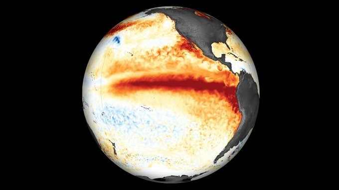
The Pacific Ocean is witnessing an extraordinary surge in temperatures as El Nino continues to strengthen, with waters off the coast of Peru recording surface temperatures as much as 8.9°C above average and subsurface temperatures soaring 10.5°C above normal.The warming is particularly striking across the eastern equatorial Pacific, where sea surface temperature anomalies exceeded 4°C in some regions last month.The scale of warming signals an intensifying El Nino, raising concerns about the potential for extreme weather disruptions across the world in the coming months. The outlook also indicates a greater than 83% chance of a strong-to-very-strong El Nino. (Photo: Windy) In parts of the central Pacific, waters warmer than 25°C extend to depths of around 150 metres, indicating that the heat is not restricted to the ocean's surface. Subsurface temperatures in the eastern Pacific have also remained more than 10°C above averageat depth, reflecting a deeper-than-normal thermocline, the boundary separating warmer surface waters from colder water below.EL NINO CONTINUES TO STRENGTHEN Ocean temperature indicators show that the warming intensified further over the past month. The Nino-3.4 index, a key measure used to monitor El Nino, reached +2.1°C, while the Nino-3 index climbed to +3.0°C.The Nino-1+2 region, located closest to the South American coast, recorded an anomaly of +3.9°C.These indices measure how much sea surface temperatures deviate from their long-term averages across different parts of the equatorial Pacific. Their simultaneous rise points to a strengthening ocean-atmosphere interaction, the defining characteristic of El Nino.Atmospheric conditions are reinforcing the pattern. Unusually strong westerly wind anomalies near the ocean surface and easterly anomalies higher in the atmosphere have extended across the equatorial Pacific. Rainfall and cloud formation have increased over the central and eastern Pacific, while Indonesia continues to experience suppressed atmospheric convection.HISTORIC EL NINO INCREASINGLY LIKELYThe US Climate Prediction Center's official outlook indicates that El Nino is likely to strengthen through the end of 2026 and persist into early 2027.The probability of a historic event exceeding the strength of previous El Nino episodes dating back to 1950 stands at 54% for September-November, 83 per cent for October-December and 70% for November-January.The outlook also indicates a greater than 83% chance of a strong-to-very-strong El Nino persisting through January-March 2027.An event of this magnitude can alter global rainfall patterns, increase the risk of droughts in some regions and intensify rainfall in others. However, the precise impacts vary by region and season, and extreme weather cannot be attributed to El Nino alone.- Ends
El Nino is boiling oceans: Pacific temperatures hit unprecedented highs
Full Article
Original Source
Read the full article at Indiatoday →KhanList aggregates and links to publicly available news content. We do not host full articles from third-party sources. Always verify important information with original sources.