
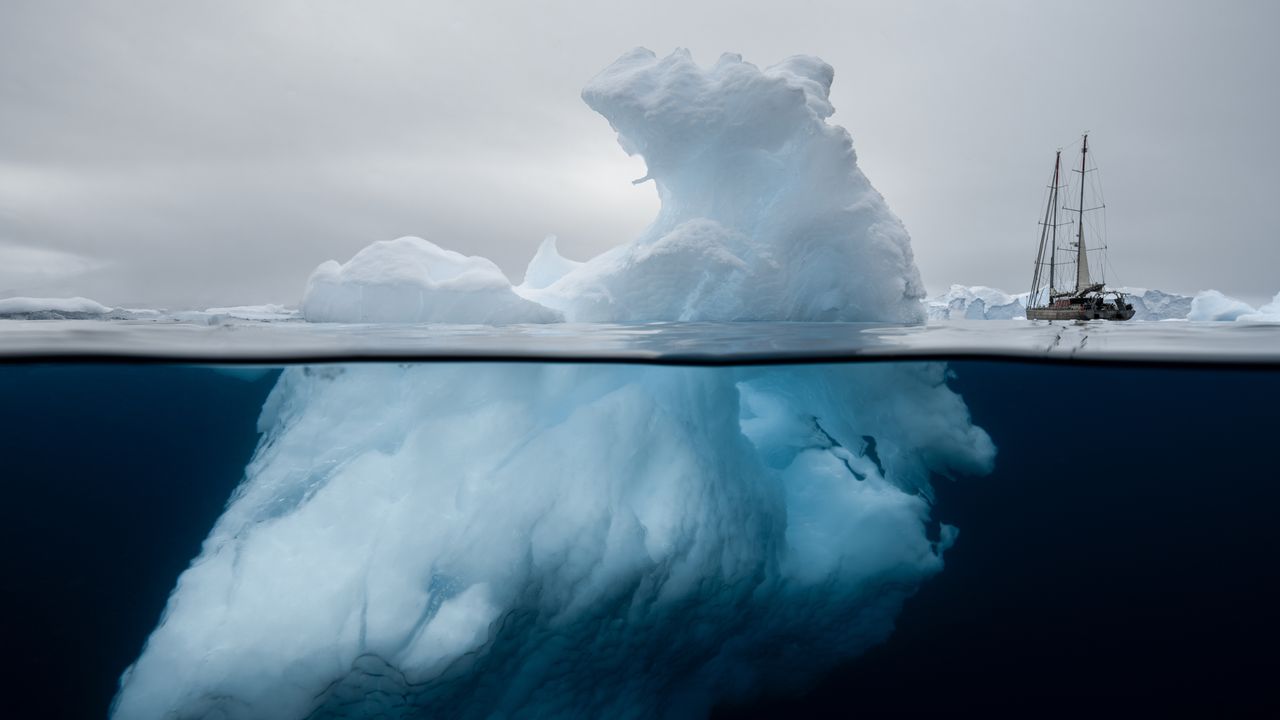
Ponant and Woods Hole Oceanographic Institution (WHOI) were featured on Condé Nast Traveler's Bright Ideas in Travel 2026. Read the full list of winners here.Each time I’ve visited the Arctic or Antarctica on assignment—something I’ve had the privilege of doing twice this year alone—I’ve been humbled by the experience of attempting to accurately the document the sheer magnitude and fragility of the Earth’s polar regions. It’s one thing to photograph charismatic animals and marine megafauna, but with such wide, open landscapes you often need a human or animal subject to give the place scale. Most times, I’m left feeling like I only captured the tip of the iceberg, so to speak.Like most environmental photographers, I still try to, because I believe that the right photo or video can make someone care about a place they might never visit. It's an age-old question in conservation, and a poignant one for the poles: regions that many people picture as empty, remote, and largely irrelevant to their lives. You can be told that the Arctic Circle and Antarctica are fragile, yes. You can intellectually grasp their endangered status, sure. But, still, you may not feel emotionally connected to their plight. That gap between knowing and feeling is exactly what a new initiative between the cruise line Ponant and the Woods Hole Oceanographic Institution (WHOI) is trying to close.Building on a partnership launched in 2025, the two organizations unveiled the Polar Ocean Image Collection in May this year: a library of more than 500 images from the Arctic and Antarctic, released for free through the Ocean Image Bank. Many of the images come from Ponant's own Polar Studio team, supplemented by the work of photographers from around the world. Overall, more than 200 photographers donated their work for non-commercial, according to Richard Vevers, who leads the WHOI’s efforts as the director of its Ocean Communication Academy and Room 71.A flick through the Polar Ocean Image Collection reveals an array of icebergs, polar bears, penguins, and endless shades of blue. An image catches my eye, what we call a “splitshot” in underwater photography: a half-submerged iceberg, dwarfing the sailboat beside it. It reminds me of the era of polar exploration, that feeling of smallness beside something so much larger than ourselves. The visual is transportive. I can almost feel a shiver down my spine—of excitement and wonder and awe.When I first visited Antarctica with Ponant in 2014, I saw firsthand how the White Continent is filled with life and movement. A fledgling penguin pecked curiously at my lens cap. A seal pup hauled itself over my legs, entirely unbothered by my presence. Icebergs that barely fit into the frame of my wide-angle lens floated past. It’s been over a decade since that trip, and I’ve been back to the polar regions multiple times since, but that first memory is still seared into my mind. When I recount the experience to Vevers, he nods knowingly. “And great photographers can capture that and allow people to see it, even those who aren’t there,” he says.Though Room 71 sounds like something out of a sci-fi story, the cryptic name is simply a reference to the fact that 71% of the planet is covered by oceans. It’s the institute’s dedicated storytelling and communications unit, with a goal to, as Vevers describes it, “reimagine how we design technology to engage new audiences." Before WHOI, Vevers spent a decade in advertising before founding The Ocean Agency, an international nonprofit for marine conservation, inspired by an “ocean epiphany.”To Vevers, seeing a place in an immersive way—either by traveling there or through photography or video—can make people care more about protecting it. He points to his own experience making Chasing Coral, a documentary that told the story of the world’s bleaching reefs, and turned that crisis into something people could feel. While difficult to measure, he believes “imagery can influence policy.” The coral bleaching images were widely used at COP21 in Paris to emphasize the importance of the 1.5 degrees Celsius target for saving coral reefs, a target that was ultimately adopted.“But there’s a gap when it comes to places like Antarctica,” Vevers says. The poles suffer from a “white nothing” problem, a common misconception that the frigid landscape is empty and lifeless. They’re places that might initially be difficult to build an emotional connection with. “Scientists really struggle to have the funding to take great photographers to capture the essence of it,” Vevers says. “The variety [of images] more than anything is what sets [this] collection apart.”In addition to the fact that fewer than 0.01% of the world’s population will ever get to visit Antarctica or the North Pole, part of our detachment from these vast regions comes from where we put them on the map. Alongside this photography effort, WHOI has been pushing an unusual piece of cartography into the conversation: the Spilhaus projection, an ocean-centered map first developed in 1942.To visualize it, imagine our existingworld map, then take it apart at the seams. Place Antarctica at the very center, and you’ll see how our different seas are actually all connected—the South Pacific spilling into the Southern Ocean, which in turn reaches into the Indian Ocean and the South Atlantic. It’s all one giant body of water, with our familiar land masses at the edges.“As terrestrial animals, we're designed to understand the world above water, not really the world below,” Vevers explains. Our maps reflect that bias, with land in the middle and ocean as leftover space. Re-focus the map on the ocean instead, and Antarctica stops looking like the isolated bottom of the world. Instead, it becomes "the beating heart of the planet," Vevers says, central, not peripheral, to life on Earth.Out in the field—or rather, on the water—that argument takes a more literal form. Under the guidance of WHOI glaciologist Dr. Catherine Walker, WHOI-MIT doctoral students have sailed on multiple voyages to Antarctica aboard Ponant’s Le Commandant Charcot, the only passenger ship with Polar Class 2 certification. Capable of breaking multi-year ice (harder sea ice that has survived at least one summer melt season) up to 8 to 10 or more feet thick, the vessel is equipped to navigate shifting glaciers and uncharted ice floes. The scientists aboard were able to measure the height of glacier fronts where ice meets ocean, and could deploy LiDAR (Light Detection and Ranging) technology to model the breakup rate of the Antarctic Ice Sheet—data usually difficult to gather by satellite, yet vital to understanding its rate of change.Since then, the partnership between Ponant and WHOI has grown into a testing ground for new technology intended to be as engaging as it is functional. There’s the underwater robot modeled after a leatherback sea turtle that surveys environments beneath the ice, and studies the behaviors of large marine animals, as well as an infrared whale-spotting camera that can flag whales up to three miles out—offering useful research data that can help commercial ships avoid deadly whale-strikes.It all builds toward the planned launch in December 2027 of "Antarctica: Ocean (Re)Imagined," a dedicated WHOI and Ponant expedition onboard Le Lyrial. This convergence of technology, travel, citizen science, and interactive programming aims to transform how guests see the ocean—turning curiosity into stewardship. The poles are just the starting point. The ambition is to eventually expand into the deep ocean and beyond, because in the end, it's not separate regions at all. It's one ocean.Whether imagery alone closes the gap between seeing and caring is a question the conservation world has debated for decades, and Vevers is honest that his conviction comes more from experience than data. But it's a bet WHOI is determined to keep making.
Can Photography Help Save the Earth’s Poles?
Full Article
Original Source
Read the full article at Cntraveler →KhanList aggregates and links to publicly available news content. We do not host full articles from third-party sources. Always verify important information with original sources.