
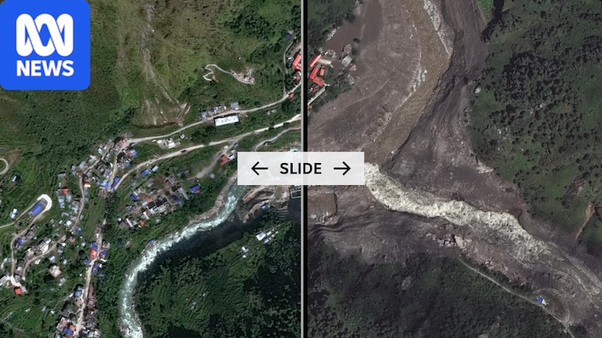
High-resolution satellite imagery has confirmed structures and settlements that had been in the destructive path of a mass of glacial water during the Nepal-Tibet floods have been wiped off the map.The flash flooding has killed at least 392 people, and hundreds are still missing, including at least 39 Australians.River levels rose by up to nine metres in just 30 minutes, catching people by surprise and causing widespread destruction.This high-quality satellite imagery has been captured by commercial satellite provider Vantor.It shows the Rasuwagadhi border point between Nepal and Tibet. The large multi-storey building and surrounding infrastructure have been completely destroyed.Before: Between Nepal and Tibet on April 19, 2024.. . After: August 27, 2026. (Vantor). .Instructions: Use left and right arrow keys to control image transition Before and after imagesSLIDE Between Nepal and Tibet on April 19, 2024. / August 27, 2026. (Vantor)In imagery captured in April 2024, the border point can be seen, along with several large buildings, a basketball court, and other structures.The image from after the flash flood shows almost all of the structures are gone. It appears the area has been reduced to bedrock.This is the same part of the Himalayan mountain range that was captured in horrific CCTV footage showing the moment the wall of water hit.Simon Gascoin, a researcher from the Center for Spatial Studies of the Biosphere, noted in a post online that Sentinel-2 satellite imagery showed the flood had impacted the area with such force that it surged up the sloping terrain for at least 2.5 kilometres.The disaster is believed to have been triggered when part of a Himalayan glacier broke off and crashed into the river below.Further downstream, the low-lying areas of the village of Syapru Besi have been swept away, leaving mud and debris.Before: Syapri Besi on October 18, 2023.. . After: August 27, 2026. (Vantor). .Instructions: Use left and right arrow keys to control image transition Before and after imagesSLIDE Syapri Besi on October 18, 2023. / August 27, 2026. (Vantor)The first image was captured in October 2023, and the second in the aftermath of this natural disaster.Some homes on the road down to the valley have not been impacted. Those closer to the water did not stand a chance against its force.Accessing this area to look for survivors is difficult because so much of the infrastructure has now been destroyed.Near Syapru Besi, a bridge that crossed the Trishuli River was visible in satellite imagery from 2023.Before: The Trishuli Bridge on October 18, 2023.. . After: August 27, 2026. (Vantor). .Instructions: Use left and right arrow keys to control image transition Before and after imagesSLIDE The Trishuli Bridge on October 18, 2023. / August 27, 2026. (Vantor)It is now gone, along with all the structures and some vegetation around it.The same happened to many other bridges in the area, with video capturing this bridge further down the valley in the town of Trishuli being swept away by a torrent of water.
Before and after: Nepal-Tibet's flood destruction
Full Article
Original Source
Read the full article at Abc →KhanList aggregates and links to publicly available news content. We do not host full articles from third-party sources. Always verify important information with original sources.