
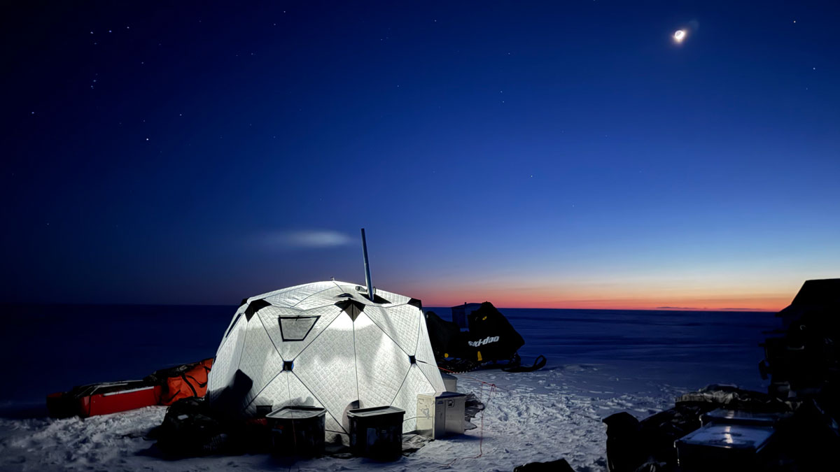
Along Alaska’s western and northern coasts, environmental change has accelerated in the 21st century, reshaping ecosystems and the communities they support [Creel et al., 2024]. Well-documented increases in coastal erosion are threatening village infrastructure [Tao et al., 2025]. Severe storms, including remnants of Pacific typhoons, are damaging homes, roads, and subsistence resources [Schaffer and Carlson, 2026]. Meanwhile, changes associated with thawing permafrost and terrain subsidence are undermining houses, roads, water and sewer systems, and other municipal infrastructure [Jones et al., 2025]. Together, these processes are transforming Alaskan coastal plains, river deltas, barrier islands, lagoons, and tundra ecosystems, with direct consequences for travel, hunting and fishing, shelter and other infrastructure, emergency response, and everyday mobility [Jorgenson et al., 2025]. Fig. 1. The COAST-X 2026 expedition, which grew from the Alaska Coastal Cooperative for Co-producing Transformative Ideas and Opportunities in the North (ACTION) project, followed a 3,200-kilometer route through western and northern Alaska. Credit: Benjamin Jones. Click image for larger version. In spring 2026, we set out to better understand these changes and challenges from the ground, traveling nearly 3,200 kilometers (2,000 miles) by snow machine (snowmobile) from Bethel to Utqiaġvik (Figure 1). The expedition, called Collaborative Observations of the Arctic Shorezone: A Traverse for Knowledge Exchange (COAST-X 2026), grew largely from a National Science Foundation (NSF)–funded project focused on strengthening communication with and between Arctic coastal communities, advancing actionable science that delivers tangible products for decisionmaking, and building technical capacity through training and leadership opportunities. That project, known as the Alaska Coastal Cooperative for Co-producing Transformative Ideas and Opportunities in the North (ACTION), supports the vision of NSF’s Navigating the New Arctic Community Office, which calls for convergent research bringing together natural, built, and social systems to better understand Arctic change and its local and global effects. In ACTION, useful Arctic science must connect physical processes, infrastructure, governance, and community priorities through sustained, reciprocal partnerships and knowledge sharing with Indigenous communities across Alaska, including Unangax̂, Alutiiq, Yup’ik, Cup’ik, Siberian Yup’ik, and Iñupiat peoples. Traveling Through Knowledge and Logistics Riding snow machines and towing camp, food, field, science, and safety gear, we covered 3,196 kilometers—equivalent to driving from Los Angeles to Seattle and then back to San Francisco. Over 19 days, our two-person snow machine team (coauthors Benjamin Jones and Phillip Wilson) traveled from the Yukon-Kuskokwim Delta, through Norton Sound and the Bering Strait region, along the Chukchi Sea coast, and, finally, to the North Slope. Riding snow machines and towing camp, food, field, science, and safety gear, we covered 3,196 kilometers (1,986 miles)—equivalent to driving from Los Angeles to Seattle and then back to San Francisco. Along the way, we visited 15 communities: Bethel, Chevak, Hooper Bay, Kotlik, Unalakleet, Elim, Nome, Brevig Mission, Shishmaref, Deering, Kotzebue, Kivalina, Point Lay, Wainwright, and Utqiaġvik, the northernmost community in the United States. Left: Phillip Wilson (left) and Benjamin Jones (second from left) meet with members of the Kotlik Corporation Board to discuss issues related to flooding and erosion. Right: Phillip Wilson travels through the hills of the Seward Peninsula, Alaska, towing gear behind his snow machine. Credit: Left: Phillip Wilson; Right: Benjamin Jones The route was logistically challenging. Some days involved more than 322 kilometers (200 miles) of travel, and long stretches crossed tundra and sea ice where little modern route information was available. Although the weather was favorable for much of the traverse, we still traveled and camped in temperatures and wind chills that at times reached −40°C (−40°F). We also camped for several days in polar bear habitat near the Chukchi Sea, where wind, visibility, snow, and terrain could change quickly. The COAST-X 2026 team was camped on the edge of Norton Sound, south of Unalakleet, when they were treated to this view of the northern lights, one of many such spectacular displays seen during the traverse. Credit: Benjamin Jones Planning the route required securing permissions to cross lands held by various public, private, tribal, and corporate organizations, and we contacted more than 40 different land management entities. Before and during the trip, experienced tundra travelers and Indigenous elders helped us think through safe travel corridors, river crossings, sea ice conditions, and route-finding decisions. Some of the most valuable guidance came through informal conversations. In Elim, for instance, a resident explained that the cold winter had made it possible to travel safely over part of the sea ice to Nome, allowing us to avoid the rough, winding Iditarod Trail through the mountains. In Point Lay, the tribal president recommended the safest and most direct route toward Wainwright and warned us about thin coastal ice along the spits connecting inlets and waterways to the frozen ocean. Some days brought clear skies, northern lights, and expansive frozen landscapes. Others brought flat light and freezing drizzle that slowed travel considerably. As we progressed north, the predominant wildlife changed too, with red fox country giving way to Arctic fox country and moose country transitioning to caribou country. Windows into Coastal Change Conversations among the authors and local communities took place in tribal council and corporation board meetings, schools, and Native village stores, as well as at community gas pumps and in subsistence use cabins. The more formal meetings clarified institutional and educational priorities, while less formal conversations allowed residents to describe observations, concerns, and experiences that might not emerge through a conventional research presentation or official meeting. Researchers stand atop eroding, ice-rich permafrost bluffs along the Beaufort Sea coast in September 2025. Credit: Benjamin Jones Alaska Native communities have observed and responded to coastal change for generations, and many have participated in scientific, engineering, and infrastructure studies for decades. Their involvement includes identifying locally important hazards, guiding researchers to affected sites, documenting environmental and infrastructure changes, interpreting maps and measurements, and explaining how erosion, flooding, and thaw affect subsistence, travel, safety, and culturally important places. Increasingly, community partners also contribute to research design, communication, monitoring, and authorship. The dialogue brought together residents, tribal and corporation representatives, educators, and researchers at a community potlatch. In Hooper Bay, coauthor Chris Maio, principal investigator of the ACTION project, helped connect conversations during the traverse with longer-term work on community-driven coastal resilience. The dialogue brought together residents, tribal and corporation representatives, educators, and researchers at a community potlatch to consider how local observations of dune erosion and flooding could inform research, hazard communication, and future planning. These issues are front and center in the minds of local residents and leaders in Hooper Bay, as one of the western Alaska communities that was severely affected by ex-typhoons Merbok (2022) and Halong (2025). Hooper Bay offered a powerful example of how coastal erosion and flooding affect both infrastructure and culture. The central Yup’ik community sits on the western edge of the Yukon-Kuskokwim Delta, where low elevation, storm exposure, and changing sea levels combine to create serious flood and erosion hazards that have intensified over time [Jorgenson et al., 2025]. Casey Ferguson (left), who leads ACTION’s Community Research Lead program, and coauthors Phillip Wilson and Jan Olson discuss flooding, erosion, and other environmental changes affecting the Yukon-Kuskokwim Delta at the Hooper Bay Community Center. Credit: Benjamin Jones A row of dunes fronting the Bering Sea has long helped protect the community from storm waves and coastal flooding. Those dunes are also part of the community’s history and cultural landscape. They include the site of Old Hooper Bay, where families once lived in sod houses built into the dunes, as well as archaeological materials that sporadically surface as the coastline erodes. Jan Olson, the ACTION community research lead in Hooper Bay and a coauthor of this article, grew up playing among the dunes and visiting them to hunt waterfowl and gather eggs. Their loss threatens not only a protective landform but also a place offering deep multigenerational cultural connections through collective childhood memories, subsistence practices, and physical evidence of earlier generations still embedded in the landscape. Erosion that occurred during the recent ex-typhoons has narrowed the protective dunes, raising concerns that future storms could breach them and increase flooding and wave damage to homes, roads, utilities, and evacuation routes. The same erosion also threatens archaeological sites, subsistence areas, and other places that preserve Hooper Bay’s cultural history. Farther north, the Iñupiat village of Point Lay, or Kali, illustrates a different coastal Arctic challenge, this one involving the interaction between infrastructure and ice-rich permafrost. In the late 1970s, the village was relocated from a nearby barrier island to its current site, much of which is underlain by large ice wedges and ice-rich permafrost. As permafrost warms, summer thaw depths increase, changing drainage patterns and disturbing the ground surface beneath roads, buildings, and infrastructure [Jones et al., 2025]. Over the past 25 years, community members have been living with the consequences of homes settling unevenly, doors and windows that no longer shut, foundation pilings losing support, sinkholes opening in roads, fire hydrants disconnecting, and buried water and sewer systems failing. Bill Tracey Sr., a longtime Point Lay resident, ACTION Community Advisory Board member, and coauthor of this article, has helped document and explain these changes. Through photographs, public testimony, and field collaboration with University of Alaska Fairbanks researchers, Tracey has shared decades of firsthand knowledge of how the village’s terrain, drainage, and infrastructure have changed over time. In Hooper Bay, Point Lay, and other communities visited by COAST-X 2026, residents repeatedly brought up concerns about access to effective evacuation routes. In Point Lay, collaborative research has centered on documenting infrastructure damage, connecting residents’ observations with measurements of ice-rich permafrost, and communicating those findings to organizations involved in housing, utilities, transportation, and community planning [Jones et al., 2025]. Some concerns were not unique to individual communities but shared by the entire region. In Hooper Bay, Point Lay, and other communities visited by COAST-X 2026, residents repeatedly brought up access to effective evacuation routes, for example: Where could people go during storms or flooding? Would roads and trails remain passable? How quickly could elders, children, and other vulnerable residents reach safer ground? We heard about the work in the village of Kivalina to address this concern by completing an evacuation road whose route was informed by community knowledge, including the need to avoid sensitive subsistence areas. Such projects demonstrate the value of community-led planning, yet they remain sparse. The recent Unmet Needs of Environmentally Threatened Alaska Native Villages report from the Alaska Native Tribal Health Consortium (ANTHC) finds that evacuation routes, protective infrastructure, managed retreat, and relocation efforts are still frequently limited by funding gaps, fragmented agency responsibilities, and inadequate technical support [ANTHC, 2024]. Toward Mobile, Community-Engaged Arctic Science Traveling by snow machine along the COAST-X 2026 route allowed us to move through the same late-winter landscape that residents use for hunting and fishing, visiting family, and traveling between communities. Impromptu gatherings with locals offered opportunities for valuable conversations and learning. Left: Out on the tundra, Jones (left) and Wilson (center) spoke with Guy Omnik from Point Hope about his subsistence hunting grounds and about changes occurring in the marine environment. Right: During one of many gas pump conversations, the researchers talked with Leo Ferreira (left), the Native Village of Point Lay Tribal Council president. Leo provided guidance on the best routes into and out of Point Lay. Credit: Benjamin Jones Our engagement with communities along the way illustrated for us how scientific tools alone cannot explain how storms affect subsistence access, how sinking roads or damaged utilities reshape daily life, how erosion of an old village site affects cultural continuity, and how uncertainty around evacuation routes can deepen concern ahead of the next environmental disaster. Phillip Wilson (left) and Benjamin Jones pose for a celebratory photo after arriving in Utqiaġvik, the last stop on their 19-day snow machine traverse. Credit: Melissa Ward Jones It also underscored the broader communication challenge that many adaptation and infrastructure programs face across rural Alaska. Local communities often lack the staffing, funding, and technical resources needed to collect and interpret relevant hazard data, while agency programs and outside technical efforts may rely on requirements, methods, and timelines that do not fully reflect local conditions, knowledge, or priorities [ANTHC, 2024]. COAST-X 2026 did not solve these structural problems, but it helped strengthen regional connections and identify where community priorities align with science and infrastructure planning. The expedition also reinforced a simple lesson: Arctic science is most useful when it grows from sustained relationships rather than one-time field campaigns. Through ACTION and related collaborations, we plan to continue working with community partners to identify research needs, connect observations with planning and decisionmaking, and communicate local concerns to scientists, agencies, and infrastructure organizations. These conversations are already shaping future research and technical support and creating opportunities for communities facing similar challenges to learn from one another. Acknowledgments We thank the National Science Foundation (award 2318375) and U.S. Army Corps Cold Regions Research and Engineering Laboratory for providing funding support for COAST-X 2026. We thank Melissa Ward Jones for assisting with field logistics and science communication during the traverse. We also thank the ACTION community and everyone along the route who made the traverse successful. References Alaska Native Tribal Health Consortium (ANTHC) (2024), Unmet needs report, Anchorage, anthc.org/resource/unmet-needs-report/. Creel, R., et al. (2024), Permafrost thaw subsidence, sea-level rise, and erosion are transforming Alaska’s Arctic coastal zone, Proc. Natl. Acad. Sci. U. S. A., 121(50), e2409411121, https://doi.org/10.1073/pnas.2409411121. Jones, B. M., et al. (2025), Climate change and infrastructure development drive ice-rich permafrost thaw in Point Lay (Kali), Alaska, Environ. Res. Ecol., 4(3), 035003, https://doi.org/10.1088/2752-664X/adf1ac. Jorgenson, M. T., et al. (2025), Interacting sea-level rise, sea-ice loss, storm flooding, erosion, and permafrost thaw threaten ecosystems, wildlife, and communities on the Yukon-Kuskokwim Delta, Earth’s Future, 13(8), e2025EF006015, https://doi.org/10.1029/2025EF006015. Schaffer, D., and C. Carlson (2026), Assessing climate-driven storm impacts on geographically isolated communities and underserved vulnerable populations, Int. J. Disaster Risk Reduct., 143, 106241, https://doi.org/10.1016/j.ijdrr.2026.106241. Tao, J., et al. (2025), Permafrost vulnerability to climate change: Understanding thaw dynamics and climate feedback of permafrost degradation, Environ. Res. Lett., 20(10), 100201, https://doi.org/10.1088/1748-9326/adfc7e. Author Information Benjamin Jones ([email protected]) and Phillip Wilson, Institute of Northern Engineering, University of Alaska Fairbanks; Jan Olson, Alaska Coastal Cooperative for Co-producing Transformative Ideas and Opportunities in the North, Hooper Bay; Bill Tracey Sr., Alaska Coastal Cooperative for Co-producing Transformative Ideas and Opportunities in the North Community Advisory Board, Point Lay; and Chris Maio, Geophysical Institute, University of Alaska Fairbanks Citation: Jones, B., P. Wilson, J. Olson, B. Tracey Sr., and C. Maio (2026), A snow machine traverse connects Arctic coastal communities, Eos, 107, https://doi.org/10.1029/2026EO260310. Published on 7 October 2026. Text © 2026. The authors. CC BY-NC-ND 3.0Except where otherwise noted, images are subject to copyright. Any reuse without express permission from the copyright owner is prohibited.
A Snow Machine Traverse Connects Arctic Coastal Communities
Full Article
Original Source
Read the full article at Eos →KhanList aggregates and links to publicly available news content. We do not host full articles from third-party sources. Always verify important information with original sources.